Vazante geodata
Vazante (Minas Gerais) is a populated place; located in Brazil in America/Sao_Paulo (GMT-3) time zone. With population of 15,459 people, there are 1194 cities with bigger population in this country. Compared to other cities in Brazil, 51% of cities are located further ↑North; 57.8% of cities are located further →East and 77.8% of cities have lower elevation than Vazante. Note1


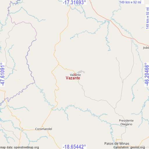
Vazante GPS coordinates[2]
17° 59' 12.984" South, 46° 54' 28.008" West
| Map corner | latitude | longitude |
|---|---|---|
| Upper-left | -17.31693°, | -47.61091° |
| Center: | -17.98694°, | -46.90778° |
| Lower-right: | -18.65442°, | -46.20466° |
| Map W x H: | 148.7×148.7 km | = 92.4×92.4mi |
| max Lat: | 2.81972° ⇑51% North |
| Vazante: | -17.98694° |
| min Lat: | ⇓49% South -33.69111° |
| min Long | Vazante | max Long |
| -72.89583° | -46.90778° | -32.41083° |
| W 42.2%⇐ | ⇒57.8% E |
Elevation
Elevation of Vazante is 665 m = 2182 ft, and this is 284.1 m = 932 ft above average elevation for this country.
| Max E: |
1603 m = 5259 ft | 22.2% |
| Vazante | 665 m 2182 ft | |
| Avg. | 380.9 m = 1250 ft | |
Min E: |
0 m = 0 ft | 77.8% |
See also: Brazil elevation on elevation.city.
Geographical zone
Vazante is located in South Torrid zone (between Equator and Tropic of Capricorn). Distance of this Southern Tropic circle is 606 km =376.6 mi to South.| Distance of | km | miles | from Vazante |
|---|---|---|---|
| Equator | 2000 | 1242.7 | to North |
| Tropic Capricorn | 606 | 376.6 | to South |
| Antarctic Circle | 5401.2 | 3356.1 | to South |
| South Pole | 8007.1 | 4975.4 | to South |


Nearby cities:
15 places around Vazante: (largest is in red/bold)
• Araguari
153.7 km =95.5 mi,  241°
241°
• Carmo do Paranaíba
128.8 km =80 mi,  151°
151°
• Catalão
111.6 km =69.3 mi,  259°
259°
• Coromandel
62.3 km =38.7 mi,  209°
209°
• Cristalina
155 km =96.3 mi,  331°
331°
• Ibiá
170.3 km =105.8 mi,  166°
166°
• Ipameri
135.7 km =84.3 mi,  282°
282°
• João Pinheiro
82.4 km =51.2 mi,  70°
70°
• Lagoa Formosa
102.6 km =63.8 mi, 149°
• Monte Carmelo
103 km =64 mi,  217°
217°
• Paracatu
85.1 km =52.9 mi,  2°
2°
• Patos de Minas
77.6 km =48.2 mi, 147°
• Patrocínio
106.8 km =66.4 mi,  184°
184°
• Pires do Rio
164.2 km =102 mi,  297°
297°
• Presidente Olegário
70.5 km =43.8 mi,  132°
132°
Sources, notices
• [Note1] Compared only with cities in Brazil existing in our database
• [Src1] Map data: © OpenStreetMap contributors (CC-BY-SA)
• [Src2] Other city data from geonames.org with taken over terms of usage.
• [Src3] Geographical zone / Annual Mean Temperature by Robert A. Rohde @ Wikipedia
