Nova Xavantina geodata
Nova Xavantina (Mato Grosso) is a populated place; located in Brazil in America/Cuiaba (GMT-4) time zone. With population of 20,639 people, there are 916 cities with bigger population in this country. Compared to other cities in Brazil, 56.9% of cities are located further ↓South; 88.7% of cities are located further →East and 54.8% of cities have higher elevation than Nova Xavantina. Note1


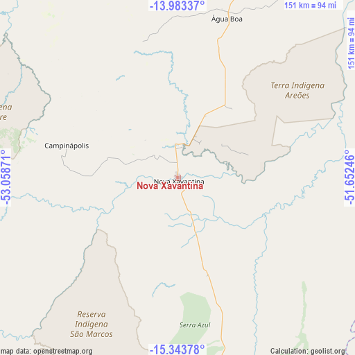
Nova Xavantina GPS coordinates[2]
14° 39' 52.668" South, 52° 21' 20.088" West
| Map corner | latitude | longitude |
|---|---|---|
| Upper-left | -13.98337°, | -53.05871° |
| Center: | -14.66463°, | -52.35558° |
| Lower-right: | -15.34378°, | -51.65246° |
| Map W x H: | 151.3×151.3 km | = 94×94mi |
| max Lat: | 2.81972° ⇑43.1% North |
| Nova Xavantina: | -14.66463° |
| min Lat: | ⇓56.9% South -33.69111° |
| min Long | Nova Xavantina | max Long |
| -72.89583° | -52.35558° | -32.41083° |
| W 11.3%⇐ | ⇒88.7% E |
Elevation
Elevation of Nova Xavantina is 271 m = 889 ft, and this is 109.9 m = 361 ft below average elevation for this country.
| Max E: |
1603 m = 5259 ft | 54.8% |
| Avg. | 380.9 m = 1250 ft | |
| Nova Xavantina | 271 m = 889 ft | |
Min E: |
0 m = 0 ft | 45.2% |
See also: Brazil elevation on elevation.city.
Geographical zone
Nova Xavantina is located in South Torrid zone (between Equator and Tropic of Capricorn). Distance of this Southern Tropic circle is 975.4 km =606.1 mi to South.| Distance of | km | miles | from Nova Xavantina |
|---|---|---|---|
| Equator | 1630.6 | 1013.2 | to North |
| Tropic Capricorn | 975.4 | 606.1 | to South |
| Antarctic Circle | 5770.6 | 3585.7 | to South |
| South Pole | 8376.5 | 5204.9 | to South |


Nearby cities:
15 places around Nova Xavantina: (largest is in red/bold)
• Aragarças
137.5 km =85.4 mi,  175°
175°
• Araguaiana
131.5 km =81.7 mi,  154°
154°
• Barra do Garças
136.7 km =84.9 mi, 175°
• Caiapônia
261.4 km =162.4 mi,  167°
167°
• Crixás
257.1 km =159.8 mi,  87°
87°
• Goiás
276.4 km =171.7 mi,  120°
120°
• Guiratinga
240 km =149.1 mi,  218°
218°
• Iporá
238 km =147.9 mi, 146°
• Itapirapuã
227 km =141.1 mi, 124°
• Itapuranga
277 km =172.1 mi,  111°
111°
• Mozarlândia
192.2 km =119.4 mi, 92°
• Piranhas
204.1 km =126.8 mi,  163°
163°
• Poxoréo
254.1 km =157.9 mi,  239°
239°
• Rubiataba
279.8 km =173.9 mi,  101°
101°
• São Miguel do Araguaia
282.6 km =175.6 mi,  56°
56°
Sources, notices
• [Note1] Compared only with cities in Brazil existing in our database
• [Src1] Map data: © OpenStreetMap contributors (CC-BY-SA)
• [Src2] Other city data from geonames.org with taken over terms of usage.
• [Src3] Geographical zone / Annual Mean Temperature by Robert A. Rohde @ Wikipedia
