Tonota geodata
Tonota (Central) is a populated place; located in Botswana in Africa/Gaborone (GMT+2) time zone. With population of 17,759 people, there are 16 cities with bigger population in this country. Compared to other cities in Botswana, 76.2% of cities are located further ↓South; 88.6% of cities are located further ←West and 62.9% of cities have higher elevation than Tonota. Note1


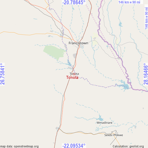
Tonota GPS coordinates[2]
21° 26' 32.496" South, 27° 27' 41.508" East
| Map corner | latitude | longitude |
|---|---|---|
| Upper-left | -20.78645°, | 26.75841° |
| Center: | -21.44236°, | 27.46153° |
| Lower-right: | -22.09534°, | 28.16466° |
| Map W x H: | 145.5×145.5 km | = 90.4×90.4mi |
| max Lat: | -17.80165° ⇑23.8% North |
| Tonota: | -21.44236° |
| min Lat: | ⇓76.2% South -26.9° |
| min Long | Tonota | max Long |
| 20.06667° | 27.46153° | 28.74946° |
| W 88.6%⇐ | ⇒11.4% E |
Elevation
Elevation of Tonota is 959 m = 3146 ft, and this is 56 m = 184 ft below average elevation for this country.
| Max E: |
1406 m = 4613 ft | 62.9% |
| Avg. | 1015 m = 3330 ft | |
| Tonota | 959 m = 3146 ft | |
Min E: |
676 m = 2218 ft | 37.1% |
See also: Botswana elevation on elevation.city.
Geographical zone
Tonota is located in South Torrid zone (between Equator and Tropic of Capricorn). Distance of this Southern Tropic circle is 221.8 km =137.8 mi to South.| Distance of | km | miles | from Tonota |
|---|---|---|---|
| Equator | 2384.2 | 1481.5 | to North |
| Tropic Capricorn | 221.8 | 137.8 | to South |
| Antarctic Circle | 5017 | 3117.4 | to South |
| South Pole | 7622.9 | 4736.6 | to South |


Nearby cities:
15 places around Tonota: (largest is in red/bold)
• Francistown
30.7 km =19.1 mi,  8°
8°
• Kalakamati
95.8 km =59.5 mi,  350°
350°
• Makaleng
63.1 km =39.2 mi,  342°
342°
• Masunga
90.9 km =56.5 mi,  359°
359°
• Mathambgwane
52 km =32.3 mi, 344°
• Mogapi
105.2 km =65.4 mi,  158°
158°
• Mogapinyana
103.8 km =64.5 mi,  172°
172°
• Moremi
125.6 km =78 mi,  180°
180°
• Mosetse
114.1 km =70.9 mi,  312°
312°
• Palapye
127.5 km =79.2 mi,  195°
195°
• Sebina
67.7 km =42.1 mi, 341°
• Sefophe
97.5 km =60.6 mi,  147°
147°
• Selebi-Phikwe
71.5 km =44.4 mi, 146°
• Tamasane
108.7 km =67.5 mi, 183°
• Tobane
72.4 km =45 mi,  141°
141°
Sources, notices
• [Note1] Compared only with cities in Botswana existing in our database
• [Src1] Map data: © OpenStreetMap contributors (CC-BY-SA)
• [Src2] Other city data from geonames.org with taken over terms of usage.
• [Src3] Geographical zone / Annual Mean Temperature by Robert A. Rohde @ Wikipedia
