Francistown geodata
Francistown (City of Francistown) is a seat of a first-order administrative division; located in Botswana in Africa/Gaborone (GMT+2) time zone. With population of 89,979 people, there is 1 city with bigger population in this country. Compared to other cities in Botswana, 80% of cities are located further ↓South; 90.5% of cities are located further ←West and 51.4% of cities have higher elevation than Francistown. Note1


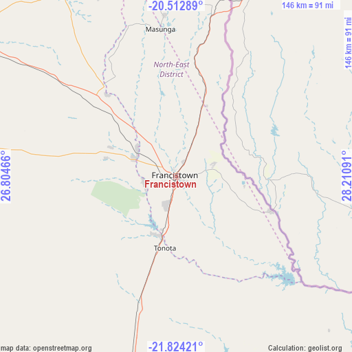
Francistown GPS coordinates[2]
21° 10' 12" South, 27° 30' 28.008" East
| Map corner | latitude | longitude |
|---|---|---|
| Upper-left | -20.51289°, | 26.80466° |
| Center: | -21.17°, | 27.50778° |
| Lower-right: | -21.82421°, | 28.21091° |
| Map W x H: | 145.8×145.8 km | = 90.6×90.6mi |
| max Lat: | -17.80165° ⇑20% North |
| Francistown: | -21.17° |
| min Lat: | ⇓80% South -26.9° |
| min Long | Francistown | max Long |
| 20.06667° | 27.50778° | 28.74946° |
| W 90.5%⇐ | ⇒9.5% E |
Elevation
Elevation of Francistown is 989 m = 3245 ft, and this is 26 m = 85 ft below average elevation for this country.
| Max E: |
1406 m = 4613 ft | 51.4% |
| Avg. | 1015 m = 3330 ft | |
| Francistown | 989 m = 3245 ft | |
Min E: |
676 m = 2218 ft | 48.6% |
See also: Francistown elevation on elevation.city.
Geographical zone
Francistown is located in South Torrid zone (between Equator and Tropic of Capricorn). Distance of this Southern Tropic circle is 252 km =156.6 mi to South.| Distance of | km | miles | from Francistown |
|---|---|---|---|
| Equator | 2353.9 | 1462.6 | to North |
| Tropic Capricorn | 252 | 156.6 | to South |
| Antarctic Circle | 5047.3 | 3136.2 | to South |
| South Pole | 7653.2 | 4755.5 | to South |


Nearby cities:
15 places around Francistown: (largest is in red/bold)
• Dukwe
130.8 km =81.3 mi,  299°
299°
• Gobojango
146.2 km =90.8 mi,  120°
120°
• Kalakamati
67.4 km =41.9 mi,  342°
342°
• Makaleng
38 km =23.6 mi,  322°
322°
• Masunga
61 km =37.9 mi,  354°
354°
• Mathambgwane
27 km =16.8 mi, 317°
• Mogapi
132.6 km =82.4 mi,  165°
165°
• Mogapinyana
133.4 km =82.9 mi,  175°
175°
• Mosetse
100.6 km =62.5 mi, 297°
• Sebina
43.1 km =26.8 mi, 321°
• Sefophe
122.2 km =75.9 mi,  157°
157°
• Selebi-Phikwe
96.4 km =59.9 mi, 158°
• Tamasane
139.2 km =86.5 mi, 184°
• Tobane
95.7 km =59.5 mi,  154°
154°
• Tonota
30.7 km =19.1 mi,  188°
188°
Sources, notices
• [Note1] Compared only with cities in Botswana existing in our database
• [Src1] Map data: © OpenStreetMap contributors (CC-BY-SA)
• [Src2] Other city data from geonames.org with taken over terms of usage.
• [Src3] Geographical zone / Annual Mean Temperature by Robert A. Rohde @ Wikipedia
