Mabuli geodata
Mabuli is a populated place; located in Botswana in Africa/Gaborone (GMT+2) time zone. With population of 1,665 people, there are 66 cities with bigger population in this country. Compared to other cities in Botswana, 97.1% of cities are located further ↑North; 77.1% of cities are located further →East and 78.1% of cities have lower elevation than Mabuli. Note1


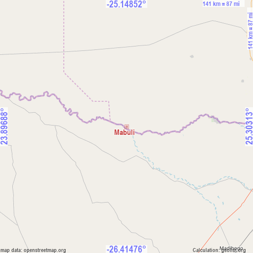
Mabuli GPS coordinates[2]
25° 46' 59.988" South, 24° 36' 0" East
| Map corner | latitude | longitude |
|---|---|---|
| Upper-left | -25.14852°, | 23.89688° |
| Center: | -25.78333°, | 24.6° |
| Lower-right: | -26.41476°, | 25.30313° |
| Map W x H: | 140.8×140.8 km | = 87.5×87.5mi |
| max Lat: | -17.80165° ⇑97.1% North |
| Mabuli: | -25.78333° |
| min Lat: | ⇓2.9% South -26.9° |
| min Long | Mabuli | max Long |
| 20.06667° | 24.6° | 28.74946° |
| W 22.9%⇐ | ⇒77.1% E |
Elevation
Elevation of Mabuli is 1113 m = 3652 ft, and this is 98 m = 322 ft above average elevation for this country.
| Max E: |
1406 m = 4613 ft | 21.9% |
| Mabuli | 1113 m 3652 ft | |
| Avg. | 1015 m = 3330 ft | |
Min E: |
676 m = 2218 ft | 78.1% |
See also: Botswana elevation on elevation.city.
Geographical zone
Mabuli is located in South temperate zone (between Tropic of Capricorn and the Antarctic Circle). Distance of this Southern Tropic circle is 260.9 km =162.1 mi to North.| Distance of | km | miles | from Mabuli |
|---|---|---|---|
| Equator | 2866.8 | 1781.3 | to North |
| Tropic Capricorn | 260.9 | 162.1 | to North |
| Antarctic Circle | 4534.3 | 2817.5 | to South |
| South Pole | 7140.2 | 4436.7 | to South |


Nearby cities:
15 places around Mabuli: (largest is in red/bold)
• Gabane
171.9 km =106.8 mi,  43°
43°
• Janeng
103.6 km =64.4 mi,  66°
66°
• Jwaneng
132 km =82 mi,  5°
5°
• Kanye
116.9 km =72.6 mi, 39°
• Khakhea
164.8 km =102.4 mi,  317°
317°
• Lobatse
124.7 km =77.5 mi,  60°
60°
• Mmokolodi
170.9 km =106.2 mi, 44°
• Molepolole
177.6 km =110.4 mi,  30°
30°
• Mosopa
139.5 km =86.7 mi, 36°
• Otse
142.2 km =88.4 mi,  53°
53°
• Ramotswa
163 km =101.3 mi, 51°
• Sekoma
169.9 km =105.6 mi,  334°
334°
• Thamaga
155.7 km =96.7 mi, 37°
• Tlhareselele
108.3 km =67.3 mi, 73°
• Werda
144.1 km =89.5 mi,  293°
293°
Sources, notices
• [Note1] Compared only with cities in Botswana existing in our database
• [Src1] Map data: © OpenStreetMap contributors (CC-BY-SA)
• [Src2] Other city data from geonames.org with taken over terms of usage.
• [Src3] Geographical zone / Annual Mean Temperature by Robert A. Rohde @ Wikipedia
