Raymond geodata
Raymond (Alberta) is a populated place; located in Canada in America/Edmonton (GMT-6) time zone. With population of 3,365 people, there are 579 cities with bigger population in this country. Compared to other cities in Canada, 69.5% of cities are located further ↓South; 77.1% of cities are located further →East and 97% of cities have lower elevation than Raymond. Note1


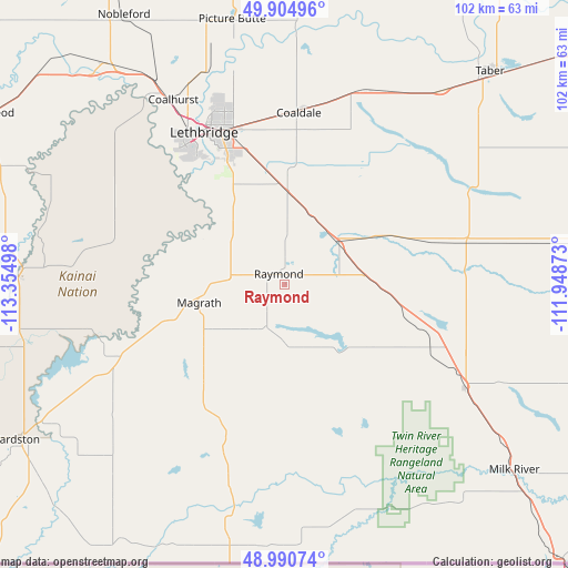
Raymond GPS coordinates[2]
49° 26' 59.928" North, 112° 39' 6.66" West
| Map corner | latitude | longitude |
|---|---|---|
| Upper-left | 49.90496°, | -113.35498° |
| Center: | 49.44998°, | -112.65185° |
| Lower-right: | 48.99074°, | -111.94873° |
| Map W x H: | 101.7×101.7 km | = 63.2×63.2mi |
| max Lat: | 73.03752° ⇑30.5% North |
| Raymond: | 49.44998° |
| min Lat: | ⇓69.5% South 42.05009° |
| min Long | Raymond | max Long |
| -139.43328° | -112.65185° | -52.70931° |
| W 22.9%⇐ | ⇒77.1% E |
Elevation
Elevation of Raymond is 964 m = 3163 ft, and this is 709.6 m = 2328 ft above average elevation for this country.
| Max E: |
1518 m = 4980 ft | 3% |
| Raymond | 964 m 3163 ft | |
| Avg. | 254.4 m = 835 ft | |
Min E: |
-2 m = -7 ft | 97% |
See also: Canada elevation on elevation.city.
Geographical zone
Raymond is located in North temperate zone (between Tropic of Cancer and the Arctic Circle). Distance of this North polar circle is 1902.9 km =1182.4 mi to North.| Distance of | km | miles | from Raymond |
|---|---|---|---|
| North Pole | 4508.7 | 2801.6 | to North |
| Arctic Circle | 1902.9 | 1182.4 | to North |
| Tropic Cancer | 2892.4 | 1797.3 | to South |
| Equator | 5498.3 | 3416.5 | to South |


Nearby cities:
15 places around Raymond: (largest is in red/bold)
• Bow Island
103.3 km =64.2 mi,  63°
63°
• Brooks
137.4 km =85.4 mi,  23°
23°
• Cardston
54.7 km =34 mi,  239°
239°
• Claresholm
93.3 km =58 mi,  314°
314°
• Coaldale
29.8 km =18.5 mi,  4°
4°
• Coalhurst
38.7 km =24 mi,  328°
328°
• Fort Macleod
62.7 km =39 mi,  298°
298°
• Lethbridge
30.3 km =18.8 mi,  336°
336°
• Magrath
16.1 km =10 mi,  256°
256°
• Nanton
128.1 km =79.6 mi,  321°
321°
• Picture Butte
49.1 km =30.5 mi,  348°
348°
• Pincher Creek
94 km =58.4 mi,  272°
272°
• Taber
52.3 km =32.5 mi,  44°
44°
• Vauxhall
78.6 km =48.8 mi,  29°
29°
• Vulcan
114 km =70.8 mi, 337°
Sources, notices
• [Note1] Compared only with cities in Canada existing in our database
• [Src1] Map data: © OpenStreetMap contributors (CC-BY-SA)
• [Src2] Other city data from geonames.org with taken over terms of usage.
• [Src3] Geographical zone / Annual Mean Temperature by Robert A. Rohde @ Wikipedia
