Esterhazy geodata
Esterhazy (Saskatchewan) is a populated place; located in Canada in America/Regina (GMT-6) time zone. With population of 2,194 people, there are 719 cities with bigger population in this country. Compared to other cities in Canada, 80.3% of cities are located further ↓South; 69.9% of cities are located further →East and 82.7% of cities have lower elevation than Esterhazy. Note1


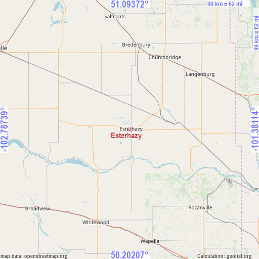
Esterhazy GPS coordinates[2]
50° 39' 0.036" North, 102° 5' 3.336" West
| Map corner | latitude | longitude |
|---|---|---|
| Upper-left | 51.09372°, | -102.78739° |
| Center: | 50.65001°, | -102.08426° |
| Lower-right: | 50.20207°, | -101.38114° |
| Map W x H: | 99.1×99.1 km | = 61.6×61.6mi |
| max Lat: | 73.03752° ⇑19.7% North |
| Esterhazy: | 50.65001° |
| min Lat: | ⇓80.3% South 42.05009° |
| min Long | Esterhazy | max Long |
| -139.43328° | -102.08426° | -52.70931° |
| W 30.1%⇐ | ⇒69.9% E |
Elevation
Elevation of Esterhazy is 516 m = 1693 ft, and this is 261.6 m = 858 ft above average elevation for this country.
| Max E: |
1518 m = 4980 ft | 17.3% |
| Esterhazy | 516 m 1693 ft | |
| Avg. | 254.4 m = 835 ft | |
Min E: |
-2 m = -7 ft | 82.7% |
See also: Canada elevation on elevation.city.
Geographical zone
Esterhazy is located in North temperate zone (between Tropic of Cancer and the Arctic Circle). Distance of this North polar circle is 1769.4 km =1099.5 mi to North.| Distance of | km | miles | from Esterhazy |
|---|---|---|---|
| North Pole | 4375.3 | 2718.7 | to North |
| Arctic Circle | 1769.4 | 1099.5 | to North |
| Tropic Cancer | 3025.8 | 1880.1 | to South |
| Equator | 5631.8 | 3499.4 | to South |


Nearby cities:
15 places around Esterhazy: (largest is in red/bold)
• Canora
112 km =69.6 mi,  347°
347°
• Carlyle
113.8 km =70.7 mi,  186°
186°
• Foam Lake
150.3 km =93.4 mi,  317°
317°
• Grenfell
65.4 km =40.6 mi,  246°
246°
• Indian Head
112.5 km =69.9 mi,  263°
263°
• Kamsack
102.7 km =63.8 mi,  7°
7°
• Kipling
72.5 km =45 mi,  212°
212°
• Langenburg
34.1 km =21.2 mi,  49°
49°
• Melville
58.5 km =36.4 mi,  300°
300°
• Moosomin
64.6 km =40.1 mi,  152°
152°
• Preeceville
150.1 km =93.3 mi,  344°
344°
• Rivers
147.9 km =91.9 mi,  117°
117°
• Roblin
82.2 km =51.1 mi,  38°
38°
• Virden
120.8 km =75.1 mi,  137°
137°
• Yorkton
68.5 km =42.6 mi, 336°
Sources, notices
• [Note1] Compared only with cities in Canada existing in our database
• [Src1] Map data: © OpenStreetMap contributors (CC-BY-SA)
• [Src2] Other city data from geonames.org with taken over terms of usage.
• [Src3] Geographical zone / Annual Mean Temperature by Robert A. Rohde @ Wikipedia
