Roblin geodata
Roblin (Manitoba) is a populated place; located in Canada in America/Winnipeg (GMT-5) time zone. With population of 1,903 people, there are 767 cities with bigger population in this country. Compared to other cities in Canada, 83.4% of cities are located further ↓South; 69.3% of cities are located further →East and 84.3% of cities have lower elevation than Roblin. Note1


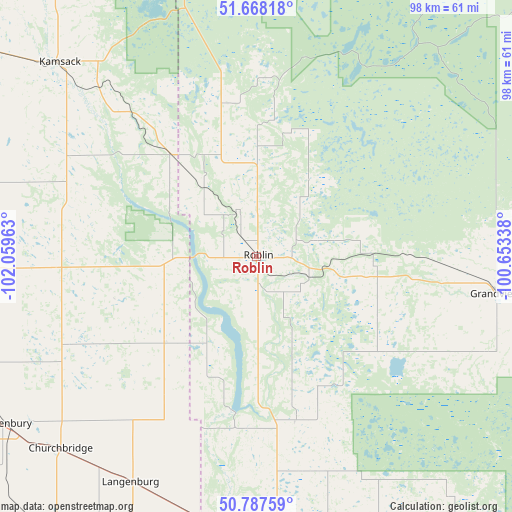
Roblin GPS coordinates[2]
51° 13' 47.964" North, 101° 21' 23.4" West
| Map corner | latitude | longitude |
|---|---|---|
| Upper-left | 51.66818°, | -102.05963° |
| Center: | 51.22999°, | -101.3565° |
| Lower-right: | 50.78759°, | -100.65338° |
| Map W x H: | 97.9×97.9 km | = 60.8×60.8mi |
| max Lat: | 73.03752° ⇑16.6% North |
| Roblin: | 51.22999° |
| min Lat: | ⇓83.4% South 42.05009° |
| min Long | Roblin | max Long |
| -139.43328° | -101.3565° | -52.70931° |
| W 30.7%⇐ | ⇒69.3% E |
Elevation
Elevation of Roblin is 553 m = 1814 ft, and this is 298.6 m = 980 ft above average elevation for this country.
| Max E: |
1518 m = 4980 ft | 15.7% |
| Roblin | 553 m 1814 ft | |
| Avg. | 254.4 m = 835 ft | |
Min E: |
-2 m = -7 ft | 84.3% |
See also: Canada elevation on elevation.city.
Geographical zone
Roblin is located in North temperate zone (between Tropic of Cancer and the Arctic Circle). Distance of this North polar circle is 1704.9 km =1059.4 mi to North.| Distance of | km | miles | from Roblin |
|---|---|---|---|
| North Pole | 4310.8 | 2678.6 | to North |
| Arctic Circle | 1704.9 | 1059.4 | to North |
| Tropic Cancer | 3090.3 | 1920.2 | to South |
| Equator | 5696.2 | 3539.5 | to South |


Nearby cities:
15 places around Roblin: (largest is in red/bold)
• Camperville
118.8 km =73.8 mi,  44°
44°
• Canora
87.1 km =54.1 mi,  300°
300°
• Dauphin
91.5 km =56.9 mi,  95°
95°
• Esterhazy
82.2 km =51.1 mi,  218°
218°
• Grenfell
143 km =88.9 mi,  230°
230°
• Kamsack
53.2 km =33.1 mi,  314°
314°
• Kipling
154.6 km =96.1 mi, 215°
• Langenburg
49.2 km =30.6 mi,  210°
210°
• Melville
106.8 km =66.4 mi,  250°
250°
• Minnedosa
152.7 km =94.9 mi,  135°
135°
• Moosomin
123.9 km =77 mi,  190°
190°
• Preeceville
120.9 km =75.1 mi, 311°
• Rivers
154.8 km =96.2 mi,  149°
149°
• Swan River
97.6 km =60.6 mi,  3°
3°
• Yorkton
77.4 km =48.1 mi,  268°
268°
Sources, notices
• [Note1] Compared only with cities in Canada existing in our database
• [Src1] Map data: © OpenStreetMap contributors (CC-BY-SA)
• [Src2] Other city data from geonames.org with taken over terms of usage.
• [Src3] Geographical zone / Annual Mean Temperature by Robert A. Rohde @ Wikipedia
