Moosomin geodata
Moosomin (Saskatchewan) is a populated place; located in Canada in America/Regina (GMT-6) time zone. With population of 2,206 people, there are 718 cities with bigger population in this country. Compared to other cities in Canada, 77.1% of cities are located further ↓South; 69.4% of cities are located further →East and 85.6% of cities have lower elevation than Moosomin. Note1


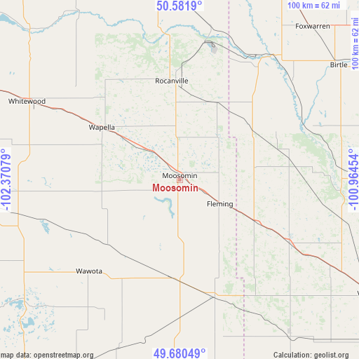
Moosomin GPS coordinates[2]
50° 7' 59.952" North, 101° 40' 3.576" West
| Map corner | latitude | longitude |
|---|---|---|
| Upper-left | 50.5819°, | -102.37079° |
| Center: | 50.13332°, | -101.66766° |
| Lower-right: | 49.68049°, | -100.96454° |
| Map W x H: | 100.2×100.2 km | = 62.3×62.3mi |
| max Lat: | 73.03752° ⇑22.9% North |
| Moosomin: | 50.13332° |
| min Lat: | ⇓77.1% South 42.05009° |
| min Long | Moosomin | max Long |
| -139.43328° | -101.66766° | -52.70931° |
| W 30.6%⇐ | ⇒69.4% E |
Elevation
Elevation of Moosomin is 581 m = 1906 ft, and this is 326.6 m = 1072 ft above average elevation for this country.
| Max E: |
1518 m = 4980 ft | 14.4% |
| Moosomin | 581 m 1906 ft | |
| Avg. | 254.4 m = 835 ft | |
Min E: |
-2 m = -7 ft | 85.6% |
See also: Canada elevation on elevation.city.
Geographical zone
Moosomin is located in North temperate zone (between Tropic of Cancer and the Arctic Circle). Distance of this North polar circle is 1826.9 km =1135.2 mi to North.| Distance of | km | miles | from Moosomin |
|---|---|---|---|
| North Pole | 4432.8 | 2754.4 | to North |
| Arctic Circle | 1826.9 | 1135.2 | to North |
| Tropic Cancer | 2968.4 | 1844.5 | to South |
| Equator | 5574.3 | 3463.7 | to South |


Nearby cities:
15 places around Moosomin: (largest is in red/bold)
• Brandon
126.6 km =78.7 mi,  104°
104°
• Carlyle
70.3 km =43.7 mi,  217°
217°
• Carnduff
107.9 km =67 mi,  185°
185°
• Esterhazy
64.6 km =40.1 mi,  332°
332°
• Grenfell
95.4 km =59.3 mi,  289°
289°
• Kipling
69 km =42.9 mi,  266°
266°
• Langenburg
79.8 km =49.6 mi,  357°
357°
• Melita
107.6 km =66.9 mi,  153°
153°
• Melville
118.3 km =73.5 mi,  317°
317°
• Minnedosa
130.4 km =81 mi,  84°
84°
• Oxbow
106.3 km =66.1 mi,  199°
199°
• Rivers
102.5 km =63.7 mi, 96°
• Roblin
123.9 km =77 mi,  10°
10°
• Souris
116 km =72.1 mi,  119°
119°
• Virden
61.2 km =38 mi, 120°
Sources, notices
• [Note1] Compared only with cities in Canada existing in our database
• [Src1] Map data: © OpenStreetMap contributors (CC-BY-SA)
• [Src2] Other city data from geonames.org with taken over terms of usage.
• [Src3] Geographical zone / Annual Mean Temperature by Robert A. Rohde @ Wikipedia
