Carlyle geodata
Carlyle (Saskatchewan) is a populated place; located in Canada in America/Regina (GMT-6) time zone. With population of 1,177 people, there are 961 cities with bigger population in this country. Compared to other cities in Canada, 71.5% of cities are located further ↓South; 70% of cities are located further →East and 88% of cities have lower elevation than Carlyle. Note1


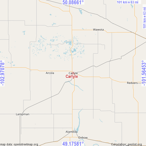
Carlyle GPS coordinates[2]
49° 38' 0.024" North, 102° 16' 3.54" West
| Map corner | latitude | longitude |
|---|---|---|
| Upper-left | 50.08661°, | -102.97078° |
| Center: | 49.63334°, | -102.26765° |
| Lower-right: | 49.17581°, | -101.56453° |
| Map W x H: | 101.3×101.3 km | = 62.9×62.9mi |
| max Lat: | 73.03752° ⇑28.5% North |
| Carlyle: | 49.63334° |
| min Lat: | ⇓71.5% South 42.05009° |
| min Long | Carlyle | max Long |
| -139.43328° | -102.26765° | -52.70931° |
| W 30%⇐ | ⇒70% E |
Elevation
Elevation of Carlyle is 630 m = 2067 ft, and this is 375.6 m = 1232 ft above average elevation for this country.
| Max E: |
1518 m = 4980 ft | 12% |
| Carlyle | 630 m 2067 ft | |
| Avg. | 254.4 m = 835 ft | |
Min E: |
-2 m = -7 ft | 88% |
See also: Canada elevation on elevation.city.
Geographical zone
Carlyle is located in North temperate zone (between Tropic of Cancer and the Arctic Circle). Distance of this North polar circle is 1882.5 km =1169.7 mi to North.| Distance of | km | miles | from Carlyle |
|---|---|---|---|
| North Pole | 4488.4 | 2789 | to North |
| Arctic Circle | 1882.5 | 1169.7 | to North |
| Tropic Cancer | 2912.8 | 1809.9 | to South |
| Equator | 5518.7 | 3429.2 | to South |


Nearby cities:
15 places around Carlyle: (largest is in red/bold)
• Carnduff
61.9 km =38.5 mi,  146°
146°
• Deloraine
137.4 km =85.4 mi,  110°
110°
• Esterhazy
113.8 km =70.7 mi,  6°
6°
• Estevan
76 km =47.2 mi,  223°
223°
• Grenfell
99.3 km =61.7 mi,  331°
331°
• Indian Head
141.4 km =87.9 mi,  315°
315°
• Kipling
58.2 km =36.2 mi, 333°
• Langenburg
140.8 km =87.5 mi,  16°
16°
• Melita
100.4 km =62.4 mi, 113°
• Melville
147.6 km =91.7 mi,  345°
345°
• Moosomin
70.3 km =43.7 mi,  37°
37°
• Oxbow
45.1 km =28 mi,  170°
170°
• Souris
144.5 km =89.8 mi,  90°
90°
• Virden
98.9 km =61.5 mi,  75°
75°
• Weyburn
114.1 km =70.9 mi,  271°
271°
Sources, notices
• [Note1] Compared only with cities in Canada existing in our database
• [Src1] Map data: © OpenStreetMap contributors (CC-BY-SA)
• [Src2] Other city data from geonames.org with taken over terms of usage.
• [Src3] Geographical zone / Annual Mean Temperature by Robert A. Rohde @ Wikipedia
