Grande Prairie geodata
Grande Prairie (Alberta) is a populated place; located in Canada in America/Edmonton (GMT-6) time zone. With population of 41,462 people, there are 119 cities with bigger population in this country. Compared to other cities in Canada, 95.5% of cities are located further ↓South; 86.8% of cities are located further →East and 89% of cities have lower elevation than Grande Prairie. Note1


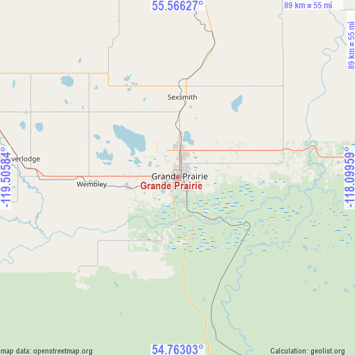
Grande Prairie GPS coordinates[2]
55° 10' 0.012" North, 118° 48' 9.756" West
| Map corner | latitude | longitude |
|---|---|---|
| Upper-left | 55.56627°, | -119.50584° |
| Center: | 55.16667°, | -118.80271° |
| Lower-right: | 54.76303°, | -118.09959° |
| Map W x H: | 89.3×89.3 km | = 55.5×55.5mi |
| max Lat: | 73.03752° ⇑4.5% North |
| Grande Prairie: | 55.16667° |
| min Lat: | ⇓95.5% South 42.05009° |
| min Long | Grande Prairie | max Long |
| -139.43328° | -118.80271° | -52.70931° |
| W 13.2%⇐ | ⇒86.8% E |
Elevation
Elevation of Grande Prairie is 653 m = 2142 ft, and this is 398.6 m = 1308 ft above average elevation for this country.
| Max E: |
1518 m = 4980 ft | 11% |
| Grande Prairie | 653 m 2142 ft | |
| Avg. | 254.4 m = 835 ft | |
Min E: |
-2 m = -7 ft | 89% |
See also: Grande Prairie elevation on elevation.city.
Geographical zone
Grande Prairie is located in North temperate zone (between Tropic of Cancer and the Arctic Circle). Distance of this North polar circle is 1267.2 km =787.4 mi to North.| Distance of | km | miles | from Grande Prairie |
|---|---|---|---|
| North Pole | 3873.1 | 2406.6 | to North |
| Arctic Circle | 1267.2 | 787.4 | to North |
| Tropic Cancer | 3528 | 2192.2 | to South |
| Equator | 6134 | 3811.5 | to South |


Nearby cities:
15 places around Grande Prairie: (largest is in red/bold)
• Beaverlodge
40.6 km =25.2 mi,  277°
277°
• Dawson Creek
112.1 km =69.7 mi,  306°
306°
• Fairview
103.4 km =64.2 mi,  14°
14°
• Falher
119 km =73.9 mi,  58°
58°
• Grande Cache
144.3 km =89.7 mi,  188°
188°
• Grimshaw
135.8 km =84.4 mi,  33°
33°
• High Prairie
149.6 km =93 mi,  78°
78°
• Peace River
152.1 km =94.5 mi,  38°
38°
• Sexsmith
20.4 km =12.7 mi,  2°
2°
• Spirit River
68.6 km =42.6 mi,  358°
358°
• Tumbler Ridge
139.3 km =86.6 mi,  268°
268°
• Valleyview
97.1 km =60.3 mi,  96°
96°
• Wedgewood
5.3 km =3.3 mi,  159°
159°
• Wembley
21.3 km =13.2 mi,  264°
264°
• Westlake
6.2 km =3.9 mi, 359°
Sources, notices
• [Note1] Compared only with cities in Canada existing in our database
• [Src1] Map data: © OpenStreetMap contributors (CC-BY-SA)
• [Src2] Other city data from geonames.org with taken over terms of usage.
• [Src3] Geographical zone / Annual Mean Temperature by Robert A. Rohde @ Wikipedia
