Wedgewood geodata
Wedgewood (Alberta) is a populated place; located in Canada in America/Edmonton (GMT-6) time zone. With population of 753 people, there are 1109 cities with bigger population in this country. Compared to other cities in Canada, 95.3% of cities are located further ↓South; 86.6% of cities are located further →East and 87.9% of cities have lower elevation than Wedgewood. Note1


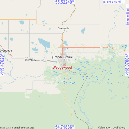
Wedgewood GPS coordinates[2]
55° 7' 20.82" North, 118° 46' 23.376" West
| Map corner | latitude | longitude |
|---|---|---|
| Upper-left | 55.52249°, | -119.47629° |
| Center: | 55.12245°, | -118.77316° |
| Lower-right: | 54.71836°, | -118.07004° |
| Map W x H: | 89.4×89.4 km | = 55.6×55.6mi |
| max Lat: | 73.03752° ⇑4.7% North |
| Wedgewood: | 55.12245° |
| min Lat: | ⇓95.3% South 42.05009° |
| min Long | Wedgewood | max Long |
| -139.43328° | -118.77316° | -52.70931° |
| W 13.4%⇐ | ⇒86.6% E |
Elevation
Elevation of Wedgewood is 624 m = 2047 ft, and this is 369.6 m = 1213 ft above average elevation for this country.
| Max E: |
1518 m = 4980 ft | 12.1% |
| Wedgewood | 624 m 2047 ft | |
| Avg. | 254.4 m = 835 ft | |
Min E: |
-2 m = -7 ft | 87.9% |
See also: Canada elevation on elevation.city.
Geographical zone
Wedgewood is located in North temperate zone (between Tropic of Cancer and the Arctic Circle). Distance of this North polar circle is 1272.1 km =790.4 mi to North.| Distance of | km | miles | from Wedgewood |
|---|---|---|---|
| North Pole | 3878 | 2409.7 | to North |
| Arctic Circle | 1272.1 | 790.4 | to North |
| Tropic Cancer | 3523.1 | 2189.2 | to South |
| Equator | 6129 | 3808.4 | to South |


Nearby cities:
15 places around Wedgewood: (largest is in red/bold)
• Beaverlodge
43.4 km =27 mi,  283°
283°
• Dawson Creek
116.6 km =72.5 mi,  307°
307°
• Fairview
107.8 km =67 mi,  13°
13°
• Falher
120.1 km =74.6 mi,  55°
55°
• Fox Creek
149.8 km =93.1 mi,  122°
122°
• Grande Cache
139.8 km =86.9 mi,  189°
189°
• Grande Prairie
5.3 km =3.3 mi,  339°
339°
• Grimshaw
138.9 km =86.3 mi,  31°
31°
• High Prairie
148.9 km =92.5 mi,  76°
76°
• Sexsmith
25.3 km =15.7 mi,  358°
358°
• Spirit River
73.6 km =45.7 mi, 356°
• Tumbler Ridge
141.2 km =87.7 mi,  270°
270°
• Valleyview
94.8 km =58.9 mi,  93°
93°
• Wembley
23.3 km =14.5 mi, 277°
• Westlake
11.3 km =7 mi,  349°
349°
Sources, notices
• [Note1] Compared only with cities in Canada existing in our database
• [Src1] Map data: © OpenStreetMap contributors (CC-BY-SA)
• [Src2] Other city data from geonames.org with taken over terms of usage.
• [Src3] Geographical zone / Annual Mean Temperature by Robert A. Rohde @ Wikipedia
