Dawson Creek geodata
Dawson Creek (British Columbia) is a populated place; located in Canada in America/Dawson_Creek (GMT-7) time zone. With population of 10,802 people, there are 295 cities with bigger population in this country. Compared to other cities in Canada, 96.6% of cities are located further ↓South; 89.3% of cities are located further →East and 89.8% of cities have lower elevation than Dawson Creek. Note1
Administrative division(s):
- Level 1: British Columbia
- Level 2: Peace River Regional District
- Level 3: Dawson Creek


Dawson Creek GPS coordinates[2]
55° 45' 35.424" North, 120° 14' 25.08" West
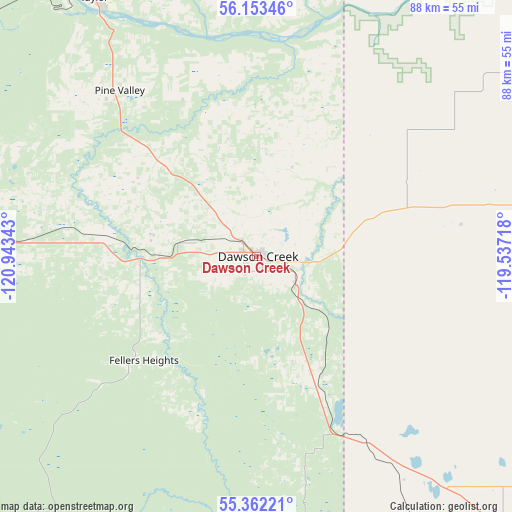
| Map corner | latitude | longitude |
|---|---|---|
| Upper-left | 56.15346°, | -120.94343° |
| Center: | 55.75984°, | -120.2403° |
| Lower-right: | 55.36221°, | -119.53718° |
| Map W x H: | 88×88 km | = 54.7×54.7mi |
| max Lat: | 73.03752° ⇑3.4% North |
| Dawson Creek: | 55.75984° |
| min Lat: | ⇓96.6% South 42.05009° |
| min Long | Dawson Creek | max Long |
| -139.43328° | -120.2403° | -52.70931° |
| W 10.7%⇐ | ⇒89.3% E |
Elevation
Elevation of Dawson Creek is 663 m = 2175 ft, and this is 408.6 m = 1341 ft above average elevation for this country.
| Max E: |
1518 m = 4980 ft | 10.2% |
| Dawson Creek | 663 m 2175 ft | |
| Avg. | 254.4 m = 835 ft | |
Min E: |
-2 m = -7 ft | 89.8% |
See also: Canada elevation on elevation.city.
Geographical zone
Dawson Creek is located in North temperate zone (between Tropic of Cancer and the Arctic Circle). Distance of this North polar circle is 1201.3 km =746.5 mi to North.| Distance of | km | miles | from Dawson Creek |
|---|---|---|---|
| North Pole | 3807.1 | 2365.6 | to North |
| Arctic Circle | 1201.3 | 746.5 | to North |
| Tropic Cancer | 3594 | 2233.2 | to South |
| Equator | 6199.9 | 3852.4 | to South |


Nearby cities:
15 places around Dawson Creek: (largest is in red/bold)
• Beaverlodge
78.8 km =49 mi,  140°
140°
• Chetwynd
87.7 km =54.5 mi,  265°
265°
• Fairview
120.5 km =74.9 mi,  73°
73°
• Falher
190.1 km =118.1 mi,  90°
90°
• Fort St. John
66.5 km =41.3 mi,  325°
325°
• Grand Haven
66.7 km =41.4 mi,  322°
322°
• Grande Prairie
112.1 km =69.7 mi,  126°
126°
• Grimshaw
170.7 km =106.1 mi, 73°
• Mackenzie
185.5 km =115.3 mi,  255°
255°
• Sexsmith
102.2 km =63.5 mi,  116°
116°
• Spirit River
87.9 km =54.6 mi, 88°
• Tumbler Ridge
84.6 km =52.6 mi,  214°
214°
• Wedgewood
116.6 km =72.5 mi, 127°
• Wembley
97.2 km =60.4 mi, 134°
• Westlake
108.4 km =67.4 mi, 123°
Sources, notices
• [Note1] Compared only with cities in Canada existing in our database
• [Src1] Map data: © OpenStreetMap contributors (CC-BY-SA)
• [Src2] Other city data from geonames.org with taken over terms of usage.
• [Src3] Geographical zone / Annual Mean Temperature by Robert A. Rohde @ Wikipedia
