Sexsmith geodata
Sexsmith (Alberta) is a populated place; located in Canada in America/Edmonton (GMT-6) time zone. With population of 2,461 people, there are 680 cities with bigger population in this country. Compared to other cities in Canada, 96.1% of cities are located further ↓South; 86.7% of cities are located further →East and 92.8% of cities have lower elevation than Sexsmith. Note1


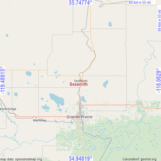
Sexsmith GPS coordinates[2]
55° 20' 59.928" North, 118° 47' 9.672" West
| Map corner | latitude | longitude |
|---|---|---|
| Upper-left | 55.74774°, | -119.48915° |
| Center: | 55.34998°, | -118.78602° |
| Lower-right: | 54.94819°, | -118.0829° |
| Map W x H: | 88.9×88.9 km | = 55.2×55.2mi |
| max Lat: | 73.03752° ⇑3.9% North |
| Sexsmith: | 55.34998° |
| min Lat: | ⇓96.1% South 42.05009° |
| min Long | Sexsmith | max Long |
| -139.43328° | -118.78602° | -52.70931° |
| W 13.3%⇐ | ⇒86.7% E |
Elevation
Elevation of Sexsmith is 719 m = 2359 ft, and this is 464.6 m = 1524 ft above average elevation for this country.
| Max E: |
1518 m = 4980 ft | 7.2% |
| Sexsmith | 719 m 2359 ft | |
| Avg. | 254.4 m = 835 ft | |
Min E: |
-2 m = -7 ft | 92.8% |
See also: Canada elevation on elevation.city.
Geographical zone
Sexsmith is located in North temperate zone (between Tropic of Cancer and the Arctic Circle). Distance of this North polar circle is 1246.8 km =774.7 mi to North.| Distance of | km | miles | from Sexsmith |
|---|---|---|---|
| North Pole | 3852.7 | 2394 | to North |
| Arctic Circle | 1246.8 | 774.7 | to North |
| Tropic Cancer | 3548.4 | 2204.9 | to South |
| Equator | 6154.3 | 3824.1 | to South |


Nearby cities:
15 places around Sexsmith: (largest is in red/bold)
• Beaverlodge
43.8 km =27.2 mi,  250°
250°
• Dawson Creek
102.2 km =63.5 mi,  296°
296°
• Fairview
83.5 km =51.9 mi,  17°
17°
• Falher
108.4 km =67.4 mi,  66°
66°
• Fort St. John
163.4 km =101.5 mi,  307°
307°
• Grande Prairie
20.4 km =12.7 mi,  182°
182°
• Grimshaw
118.6 km =73.7 mi,  38°
38°
• High Prairie
145.6 km =90.5 mi,  86°
86°
• Peace River
135.8 km =84.4 mi, 43°
• Spirit River
48.3 km =30 mi,  356°
356°
• Tumbler Ridge
142.1 km =88.3 mi,  260°
260°
• Valleyview
100.3 km =62.3 mi,  108°
108°
• Wedgewood
25.3 km =15.7 mi, 178°
• Wembley
31.4 km =19.5 mi,  224°
224°
• Westlake
14.2 km =8.8 mi, 184°
Sources, notices
• [Note1] Compared only with cities in Canada existing in our database
• [Src1] Map data: © OpenStreetMap contributors (CC-BY-SA)
• [Src2] Other city data from geonames.org with taken over terms of usage.
• [Src3] Geographical zone / Annual Mean Temperature by Robert A. Rohde @ Wikipedia
