Grimshaw geodata
Grimshaw (Alberta) is a populated place; located in Canada in America/Edmonton (GMT-6) time zone. With population of 2,560 people, there are 666 cities with bigger population in this country. Compared to other cities in Canada, 96.9% of cities are located further ↓South; 85.6% of cities are located further →East and 86.6% of cities have lower elevation than Grimshaw. Note1


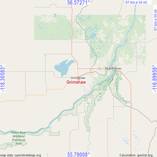
Grimshaw GPS coordinates[2]
56° 11' 0.204" North, 117° 36' 9.72" West
| Map corner | latitude | longitude |
|---|---|---|
| Upper-left | 56.57271°, | -118.30583° |
| Center: | 56.18339°, | -117.6027° |
| Lower-right: | 55.79008°, | -116.89958° |
| Map W x H: | 87×87 km | = 54.1×54.1mi |
| max Lat: | 73.03752° ⇑3.1% North |
| Grimshaw: | 56.18339° |
| min Lat: | ⇓96.9% South 42.05009° |
| min Long | Grimshaw | max Long |
| -139.43328° | -117.6027° | -52.70931° |
| W 14.4%⇐ | ⇒85.6% E |
Elevation
Elevation of Grimshaw is 598 m = 1962 ft, and this is 343.6 m = 1127 ft above average elevation for this country.
| Max E: |
1518 m = 4980 ft | 13.4% |
| Grimshaw | 598 m 1962 ft | |
| Avg. | 254.4 m = 835 ft | |
Min E: |
-2 m = -7 ft | 86.6% |
See also: Canada elevation on elevation.city.
Geographical zone
Grimshaw is located in North temperate zone (between Tropic of Cancer and the Arctic Circle). Distance of this North polar circle is 1154.2 km =717.2 mi to North.| Distance of | km | miles | from Grimshaw |
|---|---|---|---|
| North Pole | 3760.1 | 2336.4 | to North |
| Arctic Circle | 1154.2 | 717.2 | to North |
| Tropic Cancer | 3641.1 | 2262.5 | to South |
| Equator | 6247 | 3881.7 | to South |


Nearby cities:
15 places around Grimshaw: (largest is in red/bold)
• Beaverlodge
157.3 km =97.7 mi,  226°
226°
• Dawson Creek
170.7 km =106.1 mi,  253°
253°
• Fairview
50.3 km =31.3 mi,  255°
255°
• Falher
55.9 km =34.7 mi,  153°
153°
• Grande Prairie
135.8 km =84.4 mi,  213°
213°
• High Prairie
108.7 km =67.5 mi,  140°
140°
• Manning
81.6 km =50.7 mi,  359°
359°
• Paddle Prairie
196.6 km =122.2 mi,  2°
2°
• Peace River
20.1 km =12.5 mi,  72°
72°
• Sexsmith
118.6 km =73.7 mi,  218°
218°
• Spirit River
88.7 km =55.1 mi,  239°
239°
• Valleyview
125.7 km =78.1 mi,  170°
170°
• Wedgewood
138.9 km =86.3 mi, 211°
• Wembley
149.8 km =93.1 mi, 219°
• Westlake
130.7 km =81.2 mi, 215°
Sources, notices
• [Note1] Compared only with cities in Canada existing in our database
• [Src1] Map data: © OpenStreetMap contributors (CC-BY-SA)
• [Src2] Other city data from geonames.org with taken over terms of usage.
• [Src3] Geographical zone / Annual Mean Temperature by Robert A. Rohde @ Wikipedia
