Wembley geodata
Wembley (Alberta) is a populated place; located in Canada in America/Edmonton (GMT-6) time zone. With population of 1,574 people, there are 842 cities with bigger population in this country. Compared to other cities in Canada, 95.5% of cities are located further ↓South; 87.3% of cities are located further →East and 93.4% of cities have lower elevation than Wembley. Note1


Wembley GPS coordinates[2]
55° 8' 59.82" North, 119° 8' 9.672" West
| Map corner | latitude | longitude |
|---|---|---|
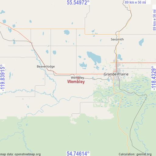
| Upper-left | 55.54972°, | -119.83915° |
| Center: | 55.14995°, | -119.13602° |
| Lower-right: | 54.74614°, | -118.4329° |
| Map W x H: | 89.3×89.3 km | = 55.5×55.5mi |
| max Lat: | 73.03752° ⇑4.5% North |
| Wembley: | 55.14995° |
| min Lat: | ⇓95.5% South 42.05009° |
| min Long | Wembley | max Long |
| -139.43328° | -119.13602° | -52.70931° |
| W 12.7%⇐ | ⇒87.3% E |
Elevation
Elevation of Wembley is 729 m = 2392 ft, and this is 474.6 m = 1557 ft above average elevation for this country.
| Max E: |
1518 m = 4980 ft | 6.6% |
| Wembley | 729 m 2392 ft | |
| Avg. | 254.4 m = 835 ft | |
Min E: |
-2 m = -7 ft | 93.4% |
See also: Canada elevation on elevation.city.
Geographical zone
Wembley is located in North temperate zone (between Tropic of Cancer and the Arctic Circle). Distance of this North polar circle is 1269.1 km =788.6 mi to North.| Distance of | km | miles | from Wembley |
|---|---|---|---|
| North Pole | 3875 | 2407.8 | to North |
| Arctic Circle | 1269.1 | 788.6 | to North |
| Tropic Cancer | 3526.2 | 2191.1 | to South |
| Equator | 6132.1 | 3810.3 | to South |


Nearby cities:
15 places around Wembley: (largest is in red/bold)
• Beaverlodge
20.4 km =12.7 mi,  291°
291°
• Dawson Creek
97.2 km =60.4 mi,  314°
314°
• Fairview
112.3 km =69.8 mi,  24°
24°
• Falher
138.1 km =85.8 mi,  61°
61°
• Fort St. John
162.9 km =101.2 mi,  318°
318°
• Grand Haven
163.5 km =101.6 mi, 317°
• Grande Cache
140.8 km =87.5 mi,  179°
179°
• Grande Prairie
21.3 km =13.2 mi,  84°
84°
• Grimshaw
149.8 km =93.1 mi,  39°
39°
• Sexsmith
31.4 km =19.5 mi, 44°
• Spirit River
72.9 km =45.3 mi, 15°
• Tumbler Ridge
118.1 km =73.4 mi,  268°
268°
• Valleyview
118 km =73.3 mi,  94°
94°
• Wedgewood
23.3 km =14.5 mi,  97°
97°
• Westlake
22.5 km =14 mi,  69°
69°
Sources, notices
• [Note1] Compared only with cities in Canada existing in our database
• [Src1] Map data: © OpenStreetMap contributors (CC-BY-SA)
• [Src2] Other city data from geonames.org with taken over terms of usage.
• [Src3] Geographical zone / Annual Mean Temperature by Robert A. Rohde @ Wikipedia
