Fairview geodata
Fairview (Alberta) is a populated place; located in Canada in America/Edmonton (GMT-6) time zone. With population of 3,312 people, there are 581 cities with bigger population in this country. Compared to other cities in Canada, 96.8% of cities are located further ↓South; 86.4% of cities are located further →East and 89.1% of cities have lower elevation than Fairview. Note1


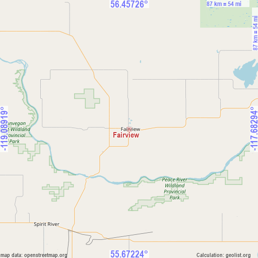
Fairview GPS coordinates[2]
56° 4' 0.3" North, 118° 23' 9.816" West
| Map corner | latitude | longitude |
|---|---|---|
| Upper-left | 56.45726°, | -119.08919° |
| Center: | 56.06675°, | -118.38606° |
| Lower-right: | 55.67224°, | -117.68294° |
| Map W x H: | 87.3×87.3 km | = 54.2×54.2mi |
| max Lat: | 73.03752° ⇑3.2% North |
| Fairview: | 56.06675° |
| min Lat: | ⇓96.8% South 42.05009° |
| min Long | Fairview | max Long |
| -139.43328° | -118.38606° | -52.70931° |
| W 13.6%⇐ | ⇒86.4% E |
Elevation
Elevation of Fairview is 655 m = 2149 ft, and this is 400.6 m = 1314 ft above average elevation for this country.
| Max E: |
1518 m = 4980 ft | 10.9% |
| Fairview | 655 m 2149 ft | |
| Avg. | 254.4 m = 835 ft | |
Min E: |
-2 m = -7 ft | 89.1% |
See also: Canada elevation on elevation.city.
Geographical zone
Fairview is located in North temperate zone (between Tropic of Cancer and the Arctic Circle). Distance of this North polar circle is 1167.1 km =725.2 mi to North.| Distance of | km | miles | from Fairview |
|---|---|---|---|
| North Pole | 3773 | 2344.4 | to North |
| Arctic Circle | 1167.1 | 725.2 | to North |
| Tropic Cancer | 3628.1 | 2254.4 | to South |
| Equator | 6234 | 3873.6 | to South |


Nearby cities:
15 places around Fairview: (largest is in red/bold)
• Beaverlodge
115.2 km =71.6 mi,  214°
214°
• Dawson Creek
120.5 km =74.9 mi,  253°
253°
• Falher
82.6 km =51.3 mi,  116°
116°
• Fort St. John
154.1 km =95.8 mi,  277°
277°
• Grande Prairie
103.4 km =64.2 mi,  194°
194°
• Grimshaw
50.3 km =31.3 mi,  75°
75°
• High Prairie
138.2 km =85.9 mi, 120°
• Manning
105.6 km =65.6 mi,  26°
26°
• Peace River
70.4 km =43.7 mi,  74°
74°
• Sexsmith
83.5 km =51.9 mi,  197°
197°
• Spirit River
42.2 km =26.2 mi,  221°
221°
• Valleyview
130.9 km =81.3 mi,  148°
148°
• Wedgewood
107.8 km =67 mi, 193°
• Wembley
112.3 km =69.8 mi, 204°
• Westlake
97.5 km =60.6 mi, 195°
Sources, notices
• [Note1] Compared only with cities in Canada existing in our database
• [Src1] Map data: © OpenStreetMap contributors (CC-BY-SA)
• [Src2] Other city data from geonames.org with taken over terms of usage.
• [Src3] Geographical zone / Annual Mean Temperature by Robert A. Rohde @ Wikipedia
