Oxbow geodata
Oxbow (Saskatchewan) is a populated place; located in Canada in America/Regina (GMT-6) time zone. With population of 1,058 people, there are 1022 cities with bigger population in this country. Compared to other cities in Canada, 66.8% of cities are located further ↓South; 69.9% of cities are located further →East and 85.8% of cities have lower elevation than Oxbow. Note1


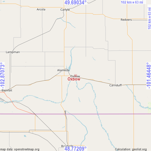
Oxbow GPS coordinates[2]
49° 14' 0.06" North, 102° 10' 3.36" West
| Map corner | latitude | longitude |
|---|---|---|
| Upper-left | 49.69034°, | -102.87073° |
| Center: | 49.23335°, | -102.1676° |
| Lower-right: | 48.77209°, | -101.46448° |
| Map W x H: | 102.1×102.1 km | = 63.4×63.4mi |
| max Lat: | 73.03752° ⇑33.2% North |
| Oxbow: | 49.23335° |
| min Lat: | ⇓66.8% South 42.05009° |
| min Long | Oxbow | max Long |
| -139.43328° | -102.1676° | -52.70931° |
| W 30.1%⇐ | ⇒69.9% E |
Elevation
Elevation of Oxbow is 582 m = 1909 ft, and this is 327.6 m = 1075 ft above average elevation for this country.
| Max E: |
1518 m = 4980 ft | 14.2% |
| Oxbow | 582 m 1909 ft | |
| Avg. | 254.4 m = 835 ft | |
Min E: |
-2 m = -7 ft | 85.8% |
See also: Canada elevation on elevation.city.
Geographical zone
Oxbow is located in North temperate zone (between Tropic of Cancer and the Arctic Circle). Distance of this North polar circle is 1926.9 km =1197.3 mi to North.| Distance of | km | miles | from Oxbow |
|---|---|---|---|
| North Pole | 4532.8 | 2816.6 | to North |
| Arctic Circle | 1926.9 | 1197.3 | to North |
| Tropic Cancer | 2868.3 | 1782.3 | to South |
| Equator | 5474.2 | 3401.5 | to South |


Nearby cities:
15 places around Oxbow: (largest is in red/bold)
• Boissevain
153.3 km =95.3 mi,  90°
90°
• Brandon
173.7 km =107.9 mi,  66°
66°
• Carlyle
45.1 km =28 mi,  350°
350°
• Carnduff
27.7 km =17.2 mi,  105°
105°
• Deloraine
121.6 km =75.6 mi, 92°
• Esterhazy
157.6 km =97.9 mi,  2°
2°
• Estevan
60.4 km =37.5 mi,  259°
259°
• Grenfell
142.6 km =88.6 mi,  337°
337°
• Kipling
102.1 km =63.4 mi, 340°
• Melita
85.1 km =52.9 mi, 87°
• Moosomin
106.3 km =66.1 mi,  19°
19°
• Rivers
164.7 km =102.3 mi,  57°
57°
• Souris
144.3 km =89.7 mi, 72°
• Virden
112.5 km =69.9 mi,  52°
52°
• Weyburn
130.9 km =81.3 mi,  291°
291°
Sources, notices
• [Note1] Compared only with cities in Canada existing in our database
• [Src1] Map data: © OpenStreetMap contributors (CC-BY-SA)
• [Src2] Other city data from geonames.org with taken over terms of usage.
• [Src3] Geographical zone / Annual Mean Temperature by Robert A. Rohde @ Wikipedia
