Neepawa geodata
Neepawa (Manitoba) is a populated place; located in Canada in America/Winnipeg (GMT-5) time zone. With population of 3,151 people, there are 598 cities with bigger population in this country. Compared to other cities in Canada, 77.5% of cities are located further ↓South; 68% of cities are located further →East and 76.1% of cities have lower elevation than Neepawa. Note1


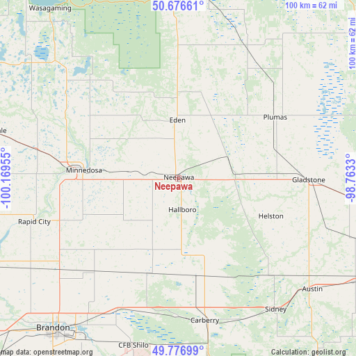
Neepawa GPS coordinates[2]
50° 13' 44.112" North, 99° 27' 59.112" West
| Map corner | latitude | longitude |
|---|---|---|
| Upper-left | 50.67661°, | -100.16955° |
| Center: | 50.22892°, | -99.46642° |
| Lower-right: | 49.77699°, | -98.7633° |
| Map W x H: | 100×100 km | = 62.1×62.1mi |
| max Lat: | 73.03752° ⇑22.5% North |
| Neepawa: | 50.22892° |
| min Lat: | ⇓77.5% South 42.05009° |
| min Long | Neepawa | max Long |
| -139.43328° | -99.46642° | -52.70931° |
| W 32%⇐ | ⇒68% E |
Elevation
Elevation of Neepawa is 374 m = 1227 ft, and this is 119.6 m = 392 ft above average elevation for this country.
| Max E: |
1518 m = 4980 ft | 23.9% |
| Neepawa | 374 m 1227 ft | |
| Avg. | 254.4 m = 835 ft | |
Min E: |
-2 m = -7 ft | 76.1% |
See also: Canada elevation on elevation.city.
Geographical zone
Neepawa is located in North temperate zone (between Tropic of Cancer and the Arctic Circle). Distance of this North polar circle is 1816.2 km =1128.5 mi to North.| Distance of | km | miles | from Neepawa |
|---|---|---|---|
| North Pole | 4422.1 | 2747.8 | to North |
| Arctic Circle | 1816.2 | 1128.5 | to North |
| Tropic Cancer | 2979 | 1851.1 | to South |
| Equator | 5584.9 | 3470.3 | to South |


Nearby cities:
15 places around Neepawa: (largest is in red/bold)
• Boissevain
118.8 km =73.8 mi,  200°
200°
• Brandon
54.9 km =34.1 mi,  219°
219°
• Carberry
40.7 km =25.3 mi,  169°
169°
• Carman
132.7 km =82.5 mi,  127°
127°
• Dauphin
110.3 km =68.5 mi,  338°
338°
• Deloraine
137.1 km =85.2 mi,  212°
212°
• Killarney
117.1 km =72.8 mi,  186°
186°
• Minnedosa
26.9 km =16.7 mi,  273°
273°
• Portage la Prairie
88.4 km =54.9 mi,  108°
108°
• Rivers
59.4 km =36.9 mi,  248°
248°
• Shilo
48.6 km =30.2 mi, 194°
• Souris
88.7 km =55.1 mi, 219°
• St. Claude
102.4 km =63.6 mi, 128°
• Virden
112.8 km =70.1 mi, 248°
• Warren
137.1 km =85.2 mi,  94°
94°
Sources, notices
• [Note1] Compared only with cities in Canada existing in our database
• [Src1] Map data: © OpenStreetMap contributors (CC-BY-SA)
• [Src2] Other city data from geonames.org with taken over terms of usage.
• [Src3] Geographical zone / Annual Mean Temperature by Robert A. Rohde @ Wikipedia
