Shilo geodata
Shilo (Manitoba) is a populated place; located in Canada in America/Winnipeg (GMT-5) time zone. With population of 1,419 people, there are 883 cities with bigger population in this country. Compared to other cities in Canada, 73.9% of cities are located further ↓South; 68.1% of cities are located further →East and 76.9% of cities have lower elevation than Shilo. Note1


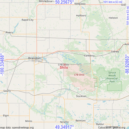
Shilo GPS coordinates[2]
49° 48' 18.324" North, 99° 37' 54.3" West
| Map corner | latitude | longitude |
|---|---|---|
| Upper-left | 50.25675°, | -100.33488° |
| Center: | 49.80509°, | -99.63175° |
| Lower-right: | 49.34917°, | -98.92863° |
| Map W x H: | 100.9×100.9 km | = 62.7×62.7mi |
| max Lat: | 73.03752° ⇑26.1% North |
| Shilo: | 49.80509° |
| min Lat: | ⇓73.9% South 42.05009° |
| min Long | Shilo | max Long |
| -139.43328° | -99.63175° | -52.70931° |
| W 31.9%⇐ | ⇒68.1% E |
Elevation
Elevation of Shilo is 381 m = 1250 ft, and this is 126.6 m = 415 ft above average elevation for this country.
| Max E: |
1518 m = 4980 ft | 23.1% |
| Shilo | 381 m 1250 ft | |
| Avg. | 254.4 m = 835 ft | |
Min E: |
-2 m = -7 ft | 76.9% |
See also: Canada elevation on elevation.city.
Geographical zone
Shilo is located in North temperate zone (between Tropic of Cancer and the Arctic Circle). Distance of this North polar circle is 1863.4 km =1157.9 mi to North.| Distance of | km | miles | from Shilo |
|---|---|---|---|
| North Pole | 4469.3 | 2777.1 | to North |
| Arctic Circle | 1863.4 | 1157.9 | to North |
| Tropic Cancer | 2931.9 | 1821.8 | to South |
| Equator | 5537.8 | 3441 | to South |


Nearby cities:
15 places around Shilo: (largest is in red/bold)
• Boissevain
70.8 km =44 mi,  205°
205°
• Brandon
23.5 km =14.6 mi,  281°
281°
• Carberry
20.7 km =12.9 mi,  69°
69°
• Carman
122.2 km =75.9 mi,  106°
106°
• Deloraine
92.5 km =57.5 mi,  222°
222°
• Killarney
69.2 km =43 mi,  181°
181°
• Melita
115.2 km =71.6 mi,  238°
238°
• Minnedosa
51.2 km =31.8 mi,  342°
342°
• Morden
129.9 km =80.7 mi,  121°
121°
• Neepawa
48.6 km =30.2 mi,  14°
14°
• Portage la Prairie
97.7 km =60.7 mi,  78°
78°
• Rivers
50.3 km =31.3 mi,  299°
299°
• Souris
49.8 km =30.9 mi,  245°
245°
• St. Claude
94.1 km =58.5 mi,  99°
99°
• Virden
93.4 km =58 mi,  273°
273°
Sources, notices
• [Note1] Compared only with cities in Canada existing in our database
• [Src1] Map data: © OpenStreetMap contributors (CC-BY-SA)
• [Src2] Other city data from geonames.org with taken over terms of usage.
• [Src3] Geographical zone / Annual Mean Temperature by Robert A. Rohde @ Wikipedia
