Souris geodata
Souris (Manitoba) is a populated place; located in Canada in America/Winnipeg (GMT-5) time zone. With population of 1,752 people, there are 802 cities with bigger population in this country. Compared to other cities in Canada, 71.3% of cities are located further ↓South; 68.8% of cities are located further →East and 79.5% of cities have lower elevation than Souris. Note1


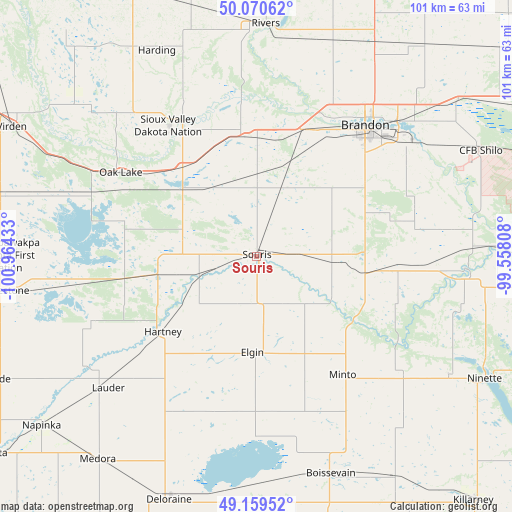
Souris GPS coordinates[2]
49° 37' 1.92" North, 100° 15' 40.32" West
| Map corner | latitude | longitude |
|---|---|---|
| Upper-left | 50.07062°, | -100.96433° |
| Center: | 49.6172°, | -100.2612° |
| Lower-right: | 49.15952°, | -99.55808° |
| Map W x H: | 101.3×101.3 km | = 62.9×62.9mi |
| max Lat: | 73.03752° ⇑28.7% North |
| Souris: | 49.6172° |
| min Lat: | ⇓71.3% South 42.05009° |
| min Long | Souris | max Long |
| -139.43328° | -100.2612° | -52.70931° |
| W 31.2%⇐ | ⇒68.8% E |
Elevation
Elevation of Souris is 428 m = 1404 ft, and this is 173.6 m = 570 ft above average elevation for this country.
| Max E: |
1518 m = 4980 ft | 20.5% |
| Souris | 428 m 1404 ft | |
| Avg. | 254.4 m = 835 ft | |
Min E: |
-2 m = -7 ft | 79.5% |
See also: Canada elevation on elevation.city.
Geographical zone
Souris is located in North temperate zone (between Tropic of Cancer and the Arctic Circle). Distance of this North polar circle is 1884.3 km =1170.8 mi to North.| Distance of | km | miles | from Souris |
|---|---|---|---|
| North Pole | 4490.1 | 2790 | to North |
| Arctic Circle | 1884.3 | 1170.8 | to North |
| Tropic Cancer | 2911 | 1808.8 | to South |
| Equator | 5516.9 | 3428 | to South |


Nearby cities:
15 places around Souris: (largest is in red/bold)
• Boissevain
45.5 km =28.3 mi,  160°
160°
• Brandon
33.8 km =21 mi,  40°
40°
• Carberry
70.5 km =43.8 mi,  66°
66°
• Carnduff
122.2 km =75.9 mi,  245°
245°
• Deloraine
50.3 km =31.3 mi,  199°
199°
• Killarney
64.8 km =40.3 mi,  138°
138°
• Melita
65.8 km =40.9 mi,  233°
233°
• Minnedosa
76 km =47.2 mi,  23°
23°
• Moosomin
116 km =72.1 mi,  299°
299°
• Neepawa
88.7 km =55.1 mi, 39°
• Oxbow
144.3 km =89.7 mi, 252°
• Rivers
46 km =28.6 mi,  1°
1°
• Shilo
49.8 km =30.9 mi, 65°
• St. Claude
138.2 km =85.9 mi,  88°
88°
• Virden
54.8 km =34.1 mi, 298°
Sources, notices
• [Note1] Compared only with cities in Canada existing in our database
• [Src1] Map data: © OpenStreetMap contributors (CC-BY-SA)
• [Src2] Other city data from geonames.org with taken over terms of usage.
• [Src3] Geographical zone / Annual Mean Temperature by Robert A. Rohde @ Wikipedia
