Killarney geodata
Killarney (Manitoba) is a populated place; located in Canada in America/Winnipeg (GMT-5) time zone. With population of 2,362 people, there are 693 cities with bigger population in this country. Compared to other cities in Canada, 65.6% of cities are located further ↓South; 68.2% of cities are located further →East and 81.6% of cities have lower elevation than Killarney. Note1


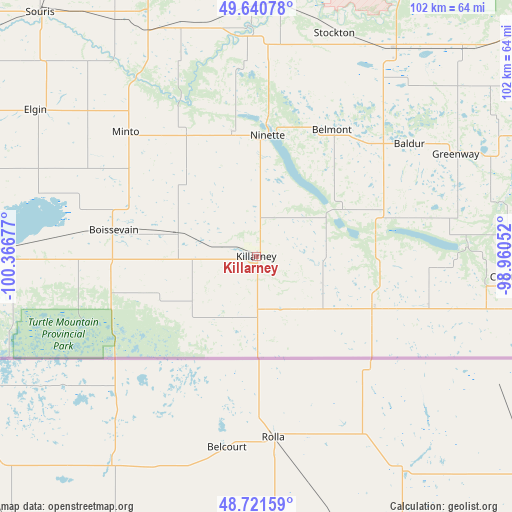
Killarney GPS coordinates[2]
49° 10' 59.952" North, 99° 39' 49.104" West
| Map corner | latitude | longitude |
|---|---|---|
| Upper-left | 49.64078°, | -100.36677° |
| Center: | 49.18332°, | -99.66364° |
| Lower-right: | 48.72159°, | -98.96052° |
| Map W x H: | 102.2×102.2 km | = 63.5×63.5mi |
| max Lat: | 73.03752° ⇑34.4% North |
| Killarney: | 49.18332° |
| min Lat: | ⇓65.6% South 42.05009° |
| min Long | Killarney | max Long |
| -139.43328° | -99.66364° | -52.70931° |
| W 31.8%⇐ | ⇒68.2% E |
Elevation
Elevation of Killarney is 495 m = 1624 ft, and this is 240.6 m = 789 ft above average elevation for this country.
| Max E: |
1518 m = 4980 ft | 18.4% |
| Killarney | 495 m 1624 ft | |
| Avg. | 254.4 m = 835 ft | |
Min E: |
-2 m = -7 ft | 81.6% |
See also: Canada elevation on elevation.city.
Geographical zone
Killarney is located in North temperate zone (between Tropic of Cancer and the Arctic Circle). Distance of this North polar circle is 1932.5 km =1200.8 mi to North.| Distance of | km | miles | from Killarney |
|---|---|---|---|
| North Pole | 4538.4 | 2820 | to North |
| Arctic Circle | 1932.5 | 1200.8 | to North |
| Tropic Cancer | 2862.8 | 1778.9 | to South |
| Equator | 5468.7 | 3398.1 | to South |


Nearby cities:
15 places around Killarney: (largest is in red/bold)
• Boissevain
29 km =18 mi,  280°
280°
• Brandon
76.7 km =47.7 mi,  344°
344°
• Carberry
79.3 km =49.3 mi,  16°
16°
• Carman
125.4 km =77.9 mi,  73°
73°
• Deloraine
60.4 km =37.5 mi,  270°
270°
• Melita
97.3 km =60.5 mi, 275°
• Minnedosa
118.8 km =73.8 mi,  353°
353°
• Morden
113.5 km =70.5 mi,  89°
89°
• Neepawa
117.1 km =72.8 mi,  6°
6°
• Rivers
103 km =64 mi, 336°
• Shilo
69.2 km =43 mi,  1°
1°
• Souris
64.8 km =40.3 mi,  318°
318°
• St. Claude
109.2 km =67.9 mi,  61°
61°
• Virden
117.9 km =73.3 mi,  309°
309°
• Winkler
125.2 km =77.8 mi, 90°
Sources, notices
• [Note1] Compared only with cities in Canada existing in our database
• [Src1] Map data: © OpenStreetMap contributors (CC-BY-SA)
• [Src2] Other city data from geonames.org with taken over terms of usage.
• [Src3] Geographical zone / Annual Mean Temperature by Robert A. Rohde @ Wikipedia
