Brandon geodata
Brandon (Manitoba) is a populated place; located in Canada in America/Winnipeg (GMT-5) time zone. With population of 26,234 people, there are 154 cities with bigger population in this country. Compared to other cities in Canada, 74.2% of cities are located further ↓South; 68.4% of cities are located further →East and 77.1% of cities have lower elevation than Brandon. Note1


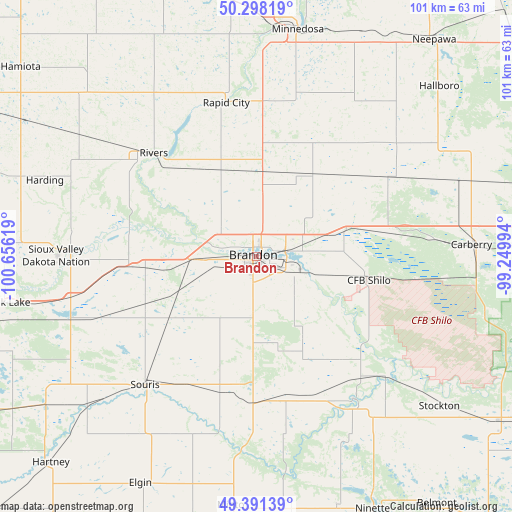
Brandon GPS coordinates[2]
49° 50' 48.912" North, 99° 57' 11.016" West
| Map corner | latitude | longitude |
|---|---|---|
| Upper-left | 50.29819°, | -100.65619° |
| Center: | 49.84692°, | -99.95306° |
| Lower-right: | 49.39139°, | -99.24994° |
| Map W x H: | 100.8×100.8 km | = 62.6×62.6mi |
| max Lat: | 73.03752° ⇑25.8% North |
| Brandon: | 49.84692° |
| min Lat: | ⇓74.2% South 42.05009° |
| min Long | Brandon | max Long |
| -139.43328° | -99.95306° | -52.70931° |
| W 31.6%⇐ | ⇒68.4% E |
Elevation
Elevation of Brandon is 383 m = 1257 ft, and this is 128.6 m = 422 ft above average elevation for this country.
| Max E: |
1518 m = 4980 ft | 22.9% |
| Brandon | 383 m 1257 ft | |
| Avg. | 254.4 m = 835 ft | |
Min E: |
-2 m = -7 ft | 77.1% |
See also: Canada elevation on elevation.city.
Geographical zone
Brandon is located in North temperate zone (between Tropic of Cancer and the Arctic Circle). Distance of this North polar circle is 1858.7 km =1154.9 mi to North.| Distance of | km | miles | from Brandon |
|---|---|---|---|
| North Pole | 4464.6 | 2774.2 | to North |
| Arctic Circle | 1858.7 | 1154.9 | to North |
| Tropic Cancer | 2936.5 | 1824.7 | to South |
| Equator | 5542.5 | 3443.9 | to South |


Nearby cities:
15 places around Brandon: (largest is in red/bold)
• Boissevain
68.9 km =42.8 mi,  186°
186°
• Carberry
42.6 km =26.5 mi,  86°
86°
• Dauphin
145 km =90.1 mi,  357°
357°
• Deloraine
82.8 km =51.4 mi,  208°
208°
• Killarney
76.7 km =47.7 mi,  164°
164°
• Melita
99 km =61.5 mi,  229°
229°
• Minnedosa
45 km =28 mi,  10°
10°
• Moosomin
126.6 km =78.7 mi,  284°
284°
• Neepawa
54.9 km =34.1 mi,  39°
39°
• Portage la Prairie
119.7 km =74.4 mi,  83°
83°
• Rivers
29 km =18 mi,  314°
314°
• Shilo
23.5 km =14.6 mi,  101°
101°
• Souris
33.8 km =21 mi,  220°
220°
• St. Claude
117.6 km =73.1 mi, 100°
• Virden
70.2 km =43.6 mi,  270°
270°
Sources, notices
• [Note1] Compared only with cities in Canada existing in our database
• [Src1] Map data: © OpenStreetMap contributors (CC-BY-SA)
• [Src2] Other city data from geonames.org with taken over terms of usage.
• [Src3] Geographical zone / Annual Mean Temperature by Robert A. Rohde @ Wikipedia
