Minnedosa geodata
Minnedosa (Manitoba) is a populated place; located in Canada in America/Winnipeg (GMT-5) time zone. With population of 2,526 people, there are 671 cities with bigger population in this country. Compared to other cities in Canada, 77.7% of cities are located further ↓South; 68.3% of cities are located further →East and 82.7% of cities have lower elevation than Minnedosa. Note1


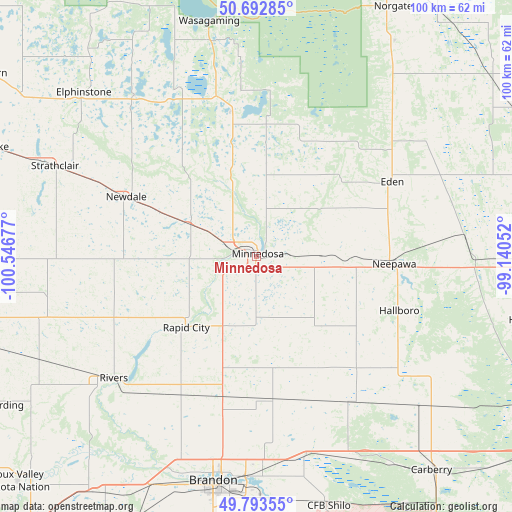
Minnedosa GPS coordinates[2]
50° 14' 43.152" North, 99° 50' 37.104" West
| Map corner | latitude | longitude |
|---|---|---|
| Upper-left | 50.69285°, | -100.54677° |
| Center: | 50.24532°, | -99.84364° |
| Lower-right: | 49.79355°, | -99.14052° |
| Map W x H: | 100×100 km | = 62.1×62.1mi |
| max Lat: | 73.03752° ⇑22.3% North |
| Minnedosa: | 50.24532° |
| min Lat: | ⇓77.7% South 42.05009° |
| min Long | Minnedosa | max Long |
| -139.43328° | -99.84364° | -52.70931° |
| W 31.7%⇐ | ⇒68.3% E |
Elevation
Elevation of Minnedosa is 516 m = 1693 ft, and this is 261.6 m = 858 ft above average elevation for this country.
| Max E: |
1518 m = 4980 ft | 17.3% |
| Minnedosa | 516 m 1693 ft | |
| Avg. | 254.4 m = 835 ft | |
Min E: |
-2 m = -7 ft | 82.7% |
See also: Canada elevation on elevation.city.
Geographical zone
Minnedosa is located in North temperate zone (between Tropic of Cancer and the Arctic Circle). Distance of this North polar circle is 1814.4 km =1127.4 mi to North.| Distance of | km | miles | from Minnedosa |
|---|---|---|---|
| North Pole | 4420.3 | 2746.6 | to North |
| Arctic Circle | 1814.4 | 1127.4 | to North |
| Tropic Cancer | 2980.8 | 1852.2 | to South |
| Equator | 5586.8 | 3471.5 | to South |


Nearby cities:
15 places around Minnedosa: (largest is in red/bold)
• Boissevain
113.8 km =70.7 mi,  187°
187°
• Brandon
45 km =28 mi, 190°
• Carberry
54.2 km =33.7 mi,  140°
140°
• Dauphin
101.6 km =63.1 mi,  351°
351°
• Deloraine
126.2 km =78.4 mi,  201°
201°
• Killarney
118.8 km =73.8 mi,  173°
173°
• Melita
136.6 km =84.9 mi,  217°
217°
• Moosomin
130.4 km =81 mi,  264°
264°
• Neepawa
26.9 km =16.7 mi,  93°
93°
• Portage la Prairie
114.7 km =71.3 mi,  105°
105°
• Rivers
37 km =23 mi,  229°
229°
• Shilo
51.2 km =31.8 mi,  162°
162°
• Souris
76 km =47.2 mi, 203°
• St. Claude
125.7 km =78.1 mi,  121°
121°
• Virden
89.3 km =55.5 mi,  240°
240°
Sources, notices
• [Note1] Compared only with cities in Canada existing in our database
• [Src1] Map data: © OpenStreetMap contributors (CC-BY-SA)
• [Src2] Other city data from geonames.org with taken over terms of usage.
• [Src3] Geographical zone / Annual Mean Temperature by Robert A. Rohde @ Wikipedia
