Boissevain geodata
Boissevain (Manitoba) is a populated place; located in Canada in America/Winnipeg (GMT-5) time zone. With population of 1,557 people, there are 848 cities with bigger population in this country. Compared to other cities in Canada, 66.6% of cities are located further ↓South; 68.5% of cities are located further →East and 82.5% of cities have lower elevation than Boissevain. Note1


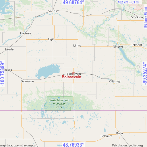
Boissevain GPS coordinates[2]
49° 13' 50.232" North, 100° 3' 21.096" West
| Map corner | latitude | longitude |
|---|---|---|
| Upper-left | 49.68764°, | -100.75899° |
| Center: | 49.23062°, | -100.05586° |
| Lower-right: | 48.76933°, | -99.35274° |
| Map W x H: | 102.1×102.1 km | = 63.4×63.4mi |
| max Lat: | 73.03752° ⇑33.4% North |
| Boissevain: | 49.23062° |
| min Lat: | ⇓66.6% South 42.05009° |
| min Long | Boissevain | max Long |
| -139.43328° | -100.05586° | -52.70931° |
| W 31.5%⇐ | ⇒68.5% E |
Elevation
Elevation of Boissevain is 514 m = 1686 ft, and this is 259.6 m = 852 ft above average elevation for this country.
| Max E: |
1518 m = 4980 ft | 17.5% |
| Boissevain | 514 m 1686 ft | |
| Avg. | 254.4 m = 835 ft | |
Min E: |
-2 m = -7 ft | 82.5% |
See also: Canada elevation on elevation.city.
Geographical zone
Boissevain is located in North temperate zone (between Tropic of Cancer and the Arctic Circle). Distance of this North polar circle is 1927.2 km =1197.5 mi to North.| Distance of | km | miles | from Boissevain |
|---|---|---|---|
| North Pole | 4533.1 | 2816.7 | to North |
| Arctic Circle | 1927.2 | 1197.5 | to North |
| Tropic Cancer | 2868 | 1782.1 | to South |
| Equator | 5473.9 | 3401.3 | to South |


Nearby cities:
15 places around Boissevain: (largest is in red/bold)
• Brandon
68.9 km =42.8 mi,  6°
6°
• Carberry
86.9 km =54 mi,  35°
35°
• Carnduff
127 km =78.9 mi,  266°
266°
• Deloraine
32.2 km =20 mi,  262°
262°
• Killarney
29 km =18 mi,  100°
100°
• Melita
68.4 km =42.5 mi, 273°
• Minnedosa
113.8 km =70.7 mi, 7°
• Morden
142 km =88.2 mi,  91°
91°
• Neepawa
118.8 km =73.8 mi,  20°
20°
• Portage la Prairie
151.5 km =94.1 mi,  56°
56°
• Rivers
90 km =55.9 mi,  351°
351°
• Shilo
70.8 km =44 mi,  25°
25°
• Souris
45.5 km =28.3 mi,  340°
340°
• St. Claude
132.7 km =82.5 mi,  68°
68°
• Virden
93.6 km =58.2 mi,  317°
317°
Sources, notices
• [Note1] Compared only with cities in Canada existing in our database
• [Src1] Map data: © OpenStreetMap contributors (CC-BY-SA)
• [Src2] Other city data from geonames.org with taken over terms of usage.
• [Src3] Geographical zone / Annual Mean Temperature by Robert A. Rohde @ Wikipedia
