Deloraine geodata
Deloraine (Manitoba) is a populated place; located in Canada in America/Winnipeg (GMT-5) time zone. With population of 1,068 people, there are 1015 cities with bigger population in this country. Compared to other cities in Canada, 65.7% of cities are located further ↓South; 68.9% of cities are located further →East and 81.8% of cities have lower elevation than Deloraine. Note1


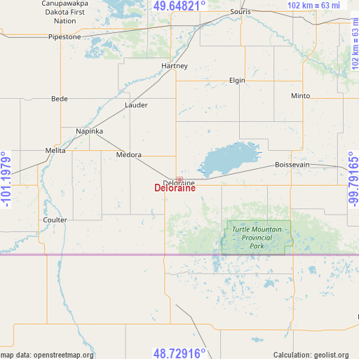
Deloraine GPS coordinates[2]
49° 11' 26.952" North, 100° 29' 41.172" West
| Map corner | latitude | longitude |
|---|---|---|
| Upper-left | 49.64821°, | -101.1979° |
| Center: | 49.19082°, | -100.49477° |
| Lower-right: | 48.72916°, | -99.79165° |
| Map W x H: | 102.2×102.2 km | = 63.5×63.5mi |
| max Lat: | 73.03752° ⇑34.3% North |
| Deloraine: | 49.19082° |
| min Lat: | ⇓65.7% South 42.05009° |
| min Long | Deloraine | max Long |
| -139.43328° | -100.49477° | -52.70931° |
| W 31.1%⇐ | ⇒68.9% E |
Elevation
Elevation of Deloraine is 503 m = 1650 ft, and this is 248.6 m = 816 ft above average elevation for this country.
| Max E: |
1518 m = 4980 ft | 18.2% |
| Deloraine | 503 m 1650 ft | |
| Avg. | 254.4 m = 835 ft | |
Min E: |
-2 m = -7 ft | 81.8% |
See also: Canada elevation on elevation.city.
Geographical zone
Deloraine is located in North temperate zone (between Tropic of Cancer and the Arctic Circle). Distance of this North polar circle is 1931.7 km =1200.3 mi to North.| Distance of | km | miles | from Deloraine |
|---|---|---|---|
| North Pole | 4537.6 | 2819.5 | to North |
| Arctic Circle | 1931.7 | 1200.3 | to North |
| Tropic Cancer | 2863.6 | 1779.4 | to South |
| Equator | 5469.5 | 3398.6 | to South |


Nearby cities:
15 places around Deloraine: (largest is in red/bold)
• Boissevain
32.2 km =20 mi,  82°
82°
• Brandon
82.8 km =51.4 mi,  28°
28°
• Carberry
111.3 km =69.2 mi,  47°
47°
• Carlyle
137.4 km =85.4 mi,  290°
290°
• Carnduff
95 km =59 mi,  268°
268°
• Killarney
60.4 km =37.5 mi,  90°
90°
• Melita
37.4 km =23.2 mi,  283°
283°
• Minnedosa
126.2 km =78.4 mi,  21°
21°
• Moosomin
134.6 km =83.6 mi,  321°
321°
• Neepawa
137.1 km =85.2 mi, 32°
• Oxbow
121.6 km =75.6 mi, 272°
• Rivers
95.2 km =59.2 mi,  11°
11°
• Shilo
92.5 km =57.5 mi,  42°
42°
• Souris
50.3 km =31.3 mi, 19°
• Virden
79.9 km =49.6 mi,  336°
336°
Sources, notices
• [Note1] Compared only with cities in Canada existing in our database
• [Src1] Map data: © OpenStreetMap contributors (CC-BY-SA)
• [Src2] Other city data from geonames.org with taken over terms of usage.
• [Src3] Geographical zone / Annual Mean Temperature by Robert A. Rohde @ Wikipedia
