Fort St. John geodata
Fort St. John (British Columbia) is a populated place; located in Canada in America/Dawson_Creek (GMT-7) time zone. With population of 17,402 people, there are 212 cities with bigger population in this country. Compared to other cities in Canada, 97.1% of cities are located further ↓South; 89.7% of cities are located further →East and 91.6% of cities have lower elevation than Fort St. John. Note1
Administrative division(s):
- Level 1: British Columbia
- Level 2: Peace River Regional District
- Level 3: Fort St. John


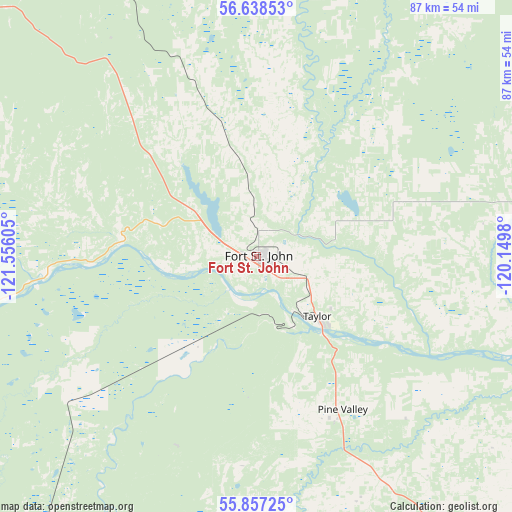
Fort St. John GPS coordinates[2]
56° 14' 59.568" North, 120° 51' 10.512" West
| Map corner | latitude | longitude |
|---|---|---|
| Upper-left | 56.63853°, | -121.55605° |
| Center: | 56.24988°, | -120.85292° |
| Lower-right: | 55.85725°, | -120.1498° |
| Map W x H: | 86.9×86.9 km | = 54×54mi |
| max Lat: | 73.03752° ⇑2.9% North |
| Fort St. John: | 56.24988° |
| min Lat: | ⇓97.1% South 42.05009° |
| min Long | Fort St. John | max Long |
| -139.43328° | -120.85292° | -52.70931° |
| W 10.3%⇐ | ⇒89.7% E |
Elevation
Elevation of Fort St. John is 696 m = 2283 ft, and this is 441.6 m = 1449 ft above average elevation for this country.
| Max E: |
1518 m = 4980 ft | 8.4% |
| Fort St. John | 696 m 2283 ft | |
| Avg. | 254.4 m = 835 ft | |
Min E: |
-2 m = -7 ft | 91.6% |
See also: Canada elevation on elevation.city.
Geographical zone
Fort St. John is located in North temperate zone (between Tropic of Cancer and the Arctic Circle). Distance of this North polar circle is 1146.8 km =712.6 mi to North.| Distance of | km | miles | from Fort St. John |
|---|---|---|---|
| North Pole | 3752.7 | 2331.8 | to North |
| Arctic Circle | 1146.8 | 712.6 | to North |
| Tropic Cancer | 3648.5 | 2267.1 | to South |
| Equator | 6254.4 | 3886.3 | to South |


Nearby cities:
15 places around Fort St. John: (largest is in red/bold)
• Beaverlodge
145.1 km =90.2 mi,  142°
142°
• Chetwynd
78.2 km =48.6 mi,  218°
218°
• Dawson Creek
66.5 km =41.3 mi,  145°
145°
• Fairview
154.1 km =95.8 mi,  97°
97°
• Grand Haven
3.4 km =2.1 mi,  237°
237°
• Grande Prairie
176.1 km =109.4 mi,  133°
133°
• Grimshaw
201.1 km =125 mi,  92°
92°
• Mackenzie
173 km =107.5 mi,  234°
234°
• Manning
211.4 km =131.4 mi,  69°
69°
• Sexsmith
163.4 km =101.5 mi, 127°
• Spirit River
135.7 km =84.3 mi,  112°
112°
• Tumbler Ridge
124.8 km =77.5 mi,  184°
184°
• Wedgewood
180.8 km =112.3 mi, 133°
• Wembley
162.9 km =101.2 mi, 138°
• Westlake
171.8 km =106.8 mi, 131°
Sources, notices
• [Note1] Compared only with cities in Canada existing in our database
• [Src1] Map data: © OpenStreetMap contributors (CC-BY-SA)
• [Src2] Other city data from geonames.org with taken over terms of usage.
• [Src3] Geographical zone / Annual Mean Temperature by Robert A. Rohde @ Wikipedia
