Bulungu geodata
Bulungu (Kwilu) is a populated place; located in Democratic Republic of the Congo in Africa/Kinshasa (GMT+1) time zone. With population of 48,344 people, there are 39 cities with bigger population in this country. Compared to other cities in Democratic Republic of the Congo, 58.6% of cities are located further ↑North; 77.1% of cities are located further →East and 70% of cities have higher elevation than Bulungu. Note1


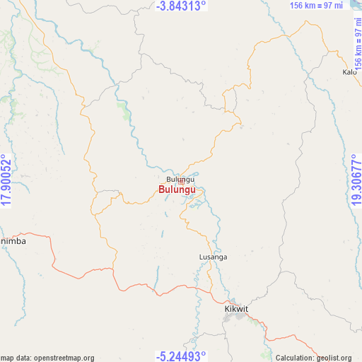
Bulungu GPS coordinates[2]
4° 32' 39.732" South, 18° 36' 13.104" East
| Map corner | latitude | longitude |
|---|---|---|
| Upper-left | -3.84313°, | 17.90052° |
| Center: | -4.54437°, | 18.60364° |
| Lower-right: | -5.24493°, | 19.30677° |
| Map W x H: | 155.9×155.9 km | = 96.9×96.9mi |
| max Lat: | 4.279° ⇑58.6% North |
| Bulungu: | -4.54437° |
| min Lat: | ⇓41.4% South -11.76097° |
| min Long | Bulungu | max Long |
| 12.37148° | 18.60364° | 30.25224° |
| W 22.9%⇐ | ⇒77.1% E |
Elevation
Elevation of Bulungu is 400 m = 1312 ft, and this is 256 m = 840 ft below average elevation for this country.
| Max E: |
1996 m = 6549 ft | 70% |
| Avg. | 656 m = 2152 ft | |
| Bulungu | 400 m = 1312 ft | |
Min E: |
11 m = 36 ft | 30% |
See also: Bulungu elevation on elevation.city.
Geographical zone
Bulungu is located in South Torrid zone (between Equator and Tropic of Capricorn). Distance of Equator is 505.3 km =314 mi to North.| Distance of | km | miles | from Bulungu |
|---|---|---|---|
| Equator | 505.3 | 314 | to North |
| Tropic Capricorn | 2100.6 | 1305.3 | to South |
| Antarctic Circle | 6895.9 | 4284.9 | to South |
| South Pole | 9501.8 | 5904.1 | to South |


Nearby cities:
15 places around Bulungu: (largest is in red/bold)
• Bandundu
192.4 km =119.6 mi,  315°
315°
• Bolobo
373.7 km =232.2 mi, 315°
• Ilebo
221.1 km =137.4 mi,  83°
83°
• Inongo
293.1 km =182.1 mi,  353°
353°
• Kasangulu
381.1 km =236.8 mi,  269°
269°
• Kasongo-Lunda
292.1 km =181.5 mi,  222°
222°
• Kikwit
60 km =37.3 mi,  156°
156°
• Kinshasa
365.5 km =227.1 mi, 273°
• Luebo
324.9 km =201.9 mi,  106°
106°
• Mangai
118.3 km =73.5 mi,  60°
60°
• Masina
356.5 km =221.5 mi, 272°
• Mushie
252.2 km =156.7 mi,  312°
312°
• Mweka
329.3 km =204.6 mi,  95°
95°
• Nioki
226.7 km =140.9 mi,  333°
333°
• Tshikapa
320 km =198.8 mi,  130°
130°
Sources, notices
• [Note1] Compared only with cities in Democratic Republic of the Congo existing in our database
• [Src1] Map data: © OpenStreetMap contributors (CC-BY-SA)
• [Src2] Other city data from geonames.org with taken over terms of usage.
• [Src3] Geographical zone / Annual Mean Temperature by Robert A. Rohde @ Wikipedia
