Gandajika geodata
Gandajika (Kasaï-Oriental) is a populated place; located in Democratic Republic of the Congo in Africa/Lubumbashi (GMT+2) time zone. With population of 154,425 people, there are 18 cities with bigger population in this country. Compared to other cities in Democratic Republic of the Congo, 88.6% of cities are located further ↑North; 58.6% of cities are located further ←West and 75.7% of cities have lower elevation than Gandajika. Note1


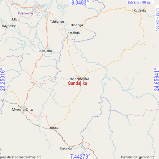
Gandajika GPS coordinates[2]
6° 44' 42.144" South, 23° 57' 11.808" East
| Map corner | latitude | longitude |
|---|---|---|
| Upper-left | -6.0463°, | 23.25016° |
| Center: | -6.74504°, | 23.95328° |
| Lower-right: | -7.44278°, | 24.65641° |
| Map W x H: | 155.3×155.3 km | = 96.5×96.5mi |
| max Lat: | 4.279° ⇑88.6% North |
| Gandajika: | -6.74504° |
| min Lat: | ⇓11.4% South -11.76097° |
| min Long | Gandajika | max Long |
| 12.37148° | 23.95328° | 30.25224° |
| W 58.6%⇐ | ⇒41.4% E |
Elevation
Elevation of Gandajika is 802 m = 2631 ft, and this is 146 m = 479 ft above average elevation for this country.
| Max E: |
1996 m = 6549 ft | 24.3% |
| Gandajika | 802 m 2631 ft | |
| Avg. | 656 m = 2152 ft | |
Min E: |
11 m = 36 ft | 75.7% |
See also: Gandajika elevation on elevation.city.
Geographical zone
Gandajika is located in South Torrid zone (between Equator and Tropic of Capricorn). Distance of Equator is 750 km =466 mi to North.| Distance of | km | miles | from Gandajika |
|---|---|---|---|
| Equator | 750 | 466 | to North |
| Tropic Capricorn | 1855.9 | 1153.2 | to South |
| Antarctic Circle | 6651.2 | 4132.9 | to South |
| South Pole | 9257.1 | 5752.1 | to South |


Nearby cities:
15 places around Gandajika: (largest is in red/bold)
• Bukama
344.4 km =214 mi,  142°
142°
• Demba
232.3 km =144.3 mi,  306°
306°
• Kabalo
336.1 km =208.8 mi,  76°
76°
• Kabinda
89.3 km =55.5 mi,  40°
40°
• Kamina
249.4 km =155 mi,  152°
152°
• Kananga
194.3 km =120.7 mi,  299°
299°
• Kongolo
369.3 km =229.5 mi,  65°
65°
• Lodja
360.6 km =224.1 mi,  353°
353°
• Lubao
249.4 km =155 mi,  52°
52°
• Luebo
319.9 km =198.8 mi, 298°
• Lusambo
204.7 km =127.2 mi,  344°
344°
• Mbuji-Mayi
78.7 km =48.9 mi,  329°
329°
• Mweka
338.3 km =210.2 mi, 308°
• Mwene-Ditu
62.6 km =38.9 mi,  242°
242°
• Tshikapa
350.2 km =217.6 mi,  275°
275°
Sources, notices
• [Note1] Compared only with cities in Democratic Republic of the Congo existing in our database
• [Src1] Map data: © OpenStreetMap contributors (CC-BY-SA)
• [Src2] Other city data from geonames.org with taken over terms of usage.
• [Src3] Geographical zone / Annual Mean Temperature by Robert A. Rohde @ Wikipedia
