Mbuji-Mayi geodata
Mbuji-Mayi (Kasaï-Oriental) is a seat of a first-order administrative division; located in Democratic Republic of the Congo in Africa/Lubumbashi (GMT+2) time zone. With population of 874,761 people, there are 2 cities with bigger population in this country. Compared to other cities in Democratic Republic of the Congo, 82.9% of cities are located further ↑North; 51.4% of cities are located further ←West and 61.4% of cities have lower elevation than Mbuji-Mayi. Note1


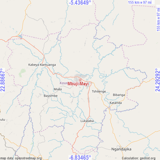
Mbuji-Mayi GPS coordinates[2]
6° 8' 9.708" South, 23° 35' 23.244" East
| Map corner | latitude | longitude |
|---|---|---|
| Upper-left | -5.43649°, | 22.88667° |
| Center: | -6.13603°, | 23.58979° |
| Lower-right: | -6.83465°, | 24.29292° |
| Map W x H: | 155.5×155.5 km | = 96.6×96.6mi |
| max Lat: | 4.279° ⇑82.9% North |
| Mbuji-Mayi: | -6.13603° |
| min Lat: | ⇓17.1% South -11.76097° |
| min Long | Mbuji-Mayi | max Long |
| 12.37148° | 23.58979° | 30.25224° |
| W 51.4%⇐ | ⇒48.6% E |
Elevation
Elevation of Mbuji-Mayi is 621 m = 2037 ft, and this is 35 m = 115 ft below average elevation for this country.
| Max E: |
1996 m = 6549 ft | 38.6% |
| Avg. | 656 m = 2152 ft | |
| Mbuji-Mayi | 621 m = 2037 ft | |
Min E: |
11 m = 36 ft | 61.4% |
See also: Mbuji-Mayi elevation on elevation.city.
Geographical zone
Mbuji-Mayi is located in South Torrid zone (between Equator and Tropic of Capricorn). Distance of Equator is 682.3 km =424 mi to North.| Distance of | km | miles | from Mbuji-Mayi |
|---|---|---|---|
| Equator | 682.3 | 424 | to North |
| Tropic Capricorn | 1923.7 | 1195.3 | to South |
| Antarctic Circle | 6718.9 | 4174.9 | to South |
| South Pole | 9324.8 | 5794.2 | to South |


Nearby cities:
15 places around Mbuji-Mayi: (largest is in red/bold)
• Demba
162.5 km =101 mi,  295°
295°
• Gandajika
78.7 km =48.9 mi,  149°
149°
• Ilebo
388.4 km =241.3 mi, 301°
• Kabalo
367.7 km =228.5 mi,  88°
88°
• Kabinda
98.6 km =61.3 mi, 90°
• Kamina
328 km =203.8 mi, 151°
• Kananga
132.4 km =82.3 mi,  281°
281°
• Kongolo
386.4 km =240.1 mi,  77°
77°
• Lodja
290.8 km =180.7 mi,  0°
0°
• Lubao
252.9 km =157.1 mi,  70°
70°
• Luebo
255.2 km =158.6 mi,  289°
289°
• Lusambo
130.1 km =80.8 mi,  352°
352°
• Mweka
266.2 km =165.4 mi, 302°
• Mwene-Ditu
98.2 km =61 mi,  188°
188°
• Tshikapa
309.9 km =192.6 mi,  264°
264°
Sources, notices
• [Note1] Compared only with cities in Democratic Republic of the Congo existing in our database
• [Src1] Map data: © OpenStreetMap contributors (CC-BY-SA)
• [Src2] Other city data from geonames.org with taken over terms of usage.
• [Src3] Geographical zone / Annual Mean Temperature by Robert A. Rohde @ Wikipedia
