Basoko geodata
Basoko (Tshopo) is a populated place; located in Democratic Republic of the Congo in Africa/Lubumbashi (GMT+2) time zone. With population of 43,709 people, there are 40 cities with bigger population in this country. Compared to other cities in Democratic Republic of the Congo, 78.6% of cities are located further ↓South; 54.3% of cities are located further ←West and 74.3% of cities have higher elevation than Basoko. Note1


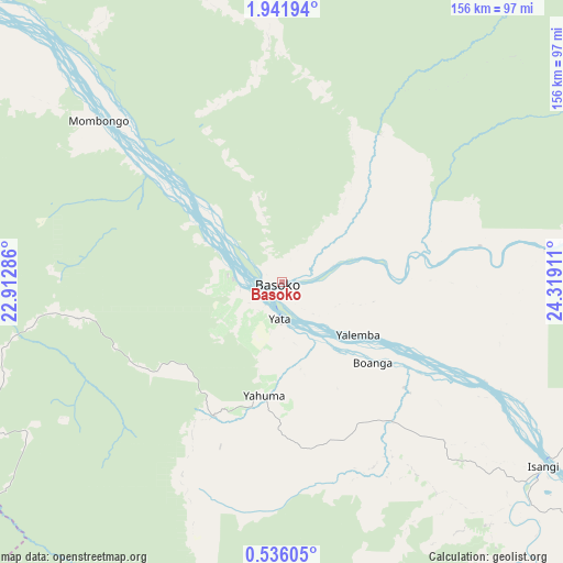
Basoko GPS coordinates[2]
1° 14' 20.724" North, 23° 36' 57.528" East
| Map corner | latitude | longitude |
|---|---|---|
| Upper-left | 1.94194°, | 22.91286° |
| Center: | 1.23909°, | 23.61598° |
| Lower-right: | 0.53605°, | 24.31911° |
| Map W x H: | 156.3×156.3 km | = 97.1×97.1mi |
| max Lat: | 4.279° ⇑21.4% North |
| Basoko: | 1.23909° |
| min Lat: | ⇓78.6% South -11.76097° |
| min Long | Basoko | max Long |
| 12.37148° | 23.61598° | 30.25224° |
| W 54.3%⇐ | ⇒45.7% E |
Elevation
Elevation of Basoko is 375 m = 1230 ft, and this is 281 m = 922 ft below average elevation for this country.
| Max E: |
1996 m = 6549 ft | 74.3% |
| Avg. | 656 m = 2152 ft | |
| Basoko | 375 m = 1230 ft | |
Min E: |
11 m = 36 ft | 25.7% |
See also: Basoko elevation on elevation.city.
Geographical zone
Basoko is located in North Torrid zone (between Equator and Tropic of Cancer). Distance of Equator is 137.8 km =85.6 mi to South.| Distance of | km | miles | from Basoko |
|---|---|---|---|
| North Pole | 9869.3 | 6132.5 | to North |
| Arctic Circle | 7263.4 | 4513.3 | to North |
| Tropic Cancer | 2468.1 | 1533.6 | to North |
| Equator | 137.8 | 85.6 | to South |


Nearby cities:
10 places around Basoko: (largest is in red/bold)
• Aketi
167.8 km =104.3 mi,  6°
6°
• Boende
348 km =216.2 mi,  240°
240°
• Bondo
286.5 km =178 mi,  1°
1°
• Bongandanga
284.3 km =176.7 mi,  276°
276°
• Bumba
165.5 km =102.8 mi,  309°
309°
• Businga
382.7 km =237.8 mi, 307°
• Buta
211.9 km =131.7 mi,  35°
35°
• Kisangani
192.7 km =119.7 mi,  114°
114°
• Lisala
254.4 km =158.1 mi,  293°
293°
• Yangambi
105.5 km =65.6 mi,  119°
119°
Sources, notices
• [Note1] Compared only with cities in Democratic Republic of the Congo existing in our database
• [Src1] Map data: © OpenStreetMap contributors (CC-BY-SA)
• [Src2] Other city data from geonames.org with taken over terms of usage.
• [Src3] Geographical zone / Annual Mean Temperature by Robert A. Rohde @ Wikipedia
