Yangambi geodata
Yangambi (Tshopo) is a populated place; located in Democratic Republic of the Congo in Africa/Lubumbashi (GMT+2) time zone. With population of 35,531 people, there are 51 cities with bigger population in this country. Compared to other cities in Democratic Republic of the Congo, 77.1% of cities are located further ↓South; 60% of cities are located further ←West and 55.7% of cities have higher elevation than Yangambi. Note1


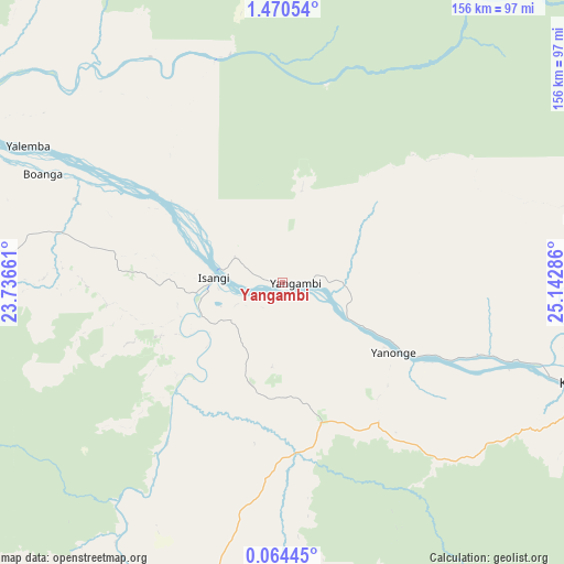
Yangambi GPS coordinates[2]
0° 46' 3.18" North, 24° 26' 23.028" East
| Map corner | latitude | longitude |
|---|---|---|
| Upper-left | 1.47054°, | 23.73661° |
| Center: | 0.76755°, | 24.43973° |
| Lower-right: | 0.06445°, | 25.14286° |
| Map W x H: | 156.3×156.3 km | = 97.1×97.1mi |
| max Lat: | 4.279° ⇑22.9% North |
| Yangambi: | 0.76755° |
| min Lat: | ⇓77.1% South -11.76097° |
| min Long | Yangambi | max Long |
| 12.37148° | 24.43973° | 30.25224° |
| W 60%⇐ | ⇒40% E |
Elevation
Elevation of Yangambi is 459 m = 1506 ft, and this is 197 m = 646 ft below average elevation for this country.
| Max E: |
1996 m = 6549 ft | 55.7% |
| Avg. | 656 m = 2152 ft | |
| Yangambi | 459 m = 1506 ft | |
Min E: |
11 m = 36 ft | 44.3% |
See also: Democratic Republic of the Congo elevation on elevation.city.
Geographical zone
Yangambi is located in North Torrid zone (between Equator and Tropic of Cancer). Distance of Equator is 85.3 km =53 mi to South.| Distance of | km | miles | from Yangambi |
|---|---|---|---|
| North Pole | 9921.7 | 6165.1 | to North |
| Arctic Circle | 7315.8 | 4545.8 | to North |
| Tropic Cancer | 2520.6 | 1566.2 | to North |
| Equator | 85.3 | 53 | to South |


Nearby cities:
12 places around Yangambi: (largest is in red/bold)
• Aketi
231 km =143.5 mi,  341°
341°
• Basoko
105.5 km =65.6 mi,  299°
299°
• Boende
412.6 km =256.4 mi,  253°
253°
• Bondo
349 km =216.9 mi,  346°
346°
• Bongandanga
383.2 km =238.1 mi,  282°
282°
• Bumba
270.1 km =167.8 mi,  305°
305°
• Buta
226.7 km =140.9 mi,  8°
8°
• Isiro
417.6 km =259.5 mi,  57°
57°
• Kindu
444.3 km =276.1 mi,  158°
158°
• Kisangani
88.1 km =54.7 mi,  108°
108°
• Lisala
359.5 km =223.4 mi, 295°
• Wamba
423.9 km =263.4 mi,  68°
68°
Sources, notices
• [Note1] Compared only with cities in Democratic Republic of the Congo existing in our database
• [Src1] Map data: © OpenStreetMap contributors (CC-BY-SA)
• [Src2] Other city data from geonames.org with taken over terms of usage.
• [Src3] Geographical zone / Annual Mean Temperature by Robert A. Rohde @ Wikipedia
