Boende geodata
Boende (Tshuapa) is a seat of a first-order administrative division; located in Democratic Republic of the Congo in Africa/Kinshasa (GMT+1) time zone. With population of 32,091 people, there are 55 cities with bigger population in this country. Compared to other cities in Democratic Republic of the Congo, 70% of cities are located further ↓South; 65.7% of cities are located further →East and 80% of cities have higher elevation than Boende. Note1


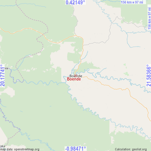
Boende GPS coordinates[2]
0° 16' 53.868" South, 20° 52' 49.908" East
| Map corner | latitude | longitude |
|---|---|---|
| Upper-left | 0.42149°, | 20.17741° |
| Center: | -0.28163°, | 20.88053° |
| Lower-right: | -0.98471°, | 21.58366° |
| Map W x H: | 156.4×156.4 km | = 97.2×97.2mi |
| max Lat: | 4.279° ⇑30% North |
| Boende: | -0.28163° |
| min Lat: | ⇓70% South -11.76097° |
| min Long | Boende | max Long |
| 12.37148° | 20.88053° | 30.25224° |
| W 34.3%⇐ | ⇒65.7% E |
Elevation
Elevation of Boende is 349 m = 1145 ft, and this is 307 m = 1007 ft below average elevation for this country.
| Max E: |
1996 m = 6549 ft | 80% |
| Avg. | 656 m = 2152 ft | |
| Boende | 349 m = 1145 ft | |
Min E: |
11 m = 36 ft | 20% |
See also: Democratic Republic of the Congo elevation on elevation.city.
Geographical zone
Boende is located in South Torrid zone (between Equator and Tropic of Capricorn). Distance of Equator is 31.3 km =19.4 mi to North.| Distance of | km | miles | from Boende |
|---|---|---|---|
| Equator | 31.3 | 19.4 | to North |
| Tropic Capricorn | 2574.6 | 1599.8 | to South |
| Antarctic Circle | 7369.9 | 4579.4 | to South |
| South Pole | 9975.7 | 6198.6 | to South |


Nearby cities:
11 places around Boende: (largest is in red/bold)
• Basoko
348 km =216.2 mi,  60°
60°
• Bongandanga
200 km =124.3 mi,  6°
6°
• Bumba
326.4 km =202.8 mi,  32°
32°
• Businga
402.5 km =250.1 mi,  0°
0°
• Gemena
412.2 km =256.1 mi,  342°
342°
• Inongo
341.4 km =212.1 mi,  237°
237°
• Lisala
279.6 km =173.7 mi, 14°
• Lukolela
420.2 km =261.1 mi,  258°
258°
• Mangai
442.1 km =274.7 mi,  199°
199°
• Mbandaka
293.6 km =182.4 mi,  277°
277°
• Yangambi
412.6 km =256.4 mi,  73°
73°
Sources, notices
• [Note1] Compared only with cities in Democratic Republic of the Congo existing in our database
• [Src1] Map data: © OpenStreetMap contributors (CC-BY-SA)
• [Src2] Other city data from geonames.org with taken over terms of usage.
• [Src3] Geographical zone / Annual Mean Temperature by Robert A. Rohde @ Wikipedia
