Loango geodata
Loango (Kouilou) is a seat of a first-order administrative division; located in Republic of the Congo in Africa/Brazzaville (GMT+1) time zone. In our database, there are 18 cities with bigger population. Compared to other cities in Republic of the Congo, 89.5% of cities are located further ↑North; 100% of cities are located further →East and 89.5% of cities have higher elevation than Loango. Note1


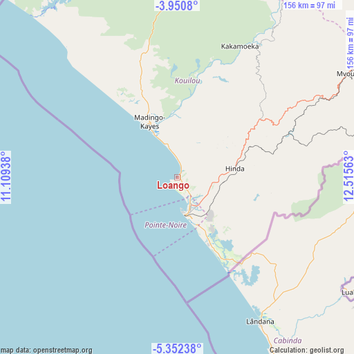
Loango GPS coordinates[2]
4° 39' 6.984" South, 11° 48' 45" East
| Map corner | latitude | longitude |
|---|---|---|
| Upper-left | -3.9508°, | 11.10938° |
| Center: | -4.65194°, | 11.8125° |
| Lower-right: | -5.35238°, | 12.51563° |
| Map W x H: | 155.8×155.8 km | = 96.8×96.8mi |
| max Lat: | 1.64806° ⇑89.5% North |
| Loango: | -4.65194° |
| min Lat: | ⇓10.5% South -4.77609° |
| min Long | Loango | max Long |
| 11.8125° | 11.8125° | 18.05981° |
| W 0%⇐ | ⇒100% E |
Elevation
Elevation of Loango is 13 m = 43 ft, and this is 306 m = 1004 ft below average elevation for this country.
| Max E: |
790 m = 2592 ft | 89.5% |
| Avg. | 319 m = 1047 ft | |
| Loango | 13 m = 43 ft | |
Min E: |
7 m = 23 ft | 10.5% |
See also: Republic of the Congo elevation on elevation.city.
Geographical zone
Loango is located in South Torrid zone (between Equator and Tropic of Capricorn). Distance of Equator is 517.2 km =321.4 mi to North.| Distance of | km | miles | from Loango |
|---|---|---|---|
| Equator | 517.2 | 321.4 | to North |
| Tropic Capricorn | 2088.7 | 1297.9 | to South |
| Antarctic Circle | 6883.9 | 4277.5 | to South |
| South Pole | 9489.8 | 5896.7 | to South |


Nearby cities:
12 places around Loango: (largest is in red/bold)
• Boukiéro
388.2 km =241.2 mi,  82°
82°
• Brazzaville
387.1 km =240.5 mi, 83°
• Djambala
401.7 km =249.6 mi,  54°
54°
• Dolisie
107.3 km =66.7 mi,  61°
61°
• Kayes
170.8 km =106.1 mi,  73°
73°
• Kinkala
328.8 km =204.3 mi, 84°
• Loandjili
12.6 km =7.8 mi,  156°
156°
• Madingou
200.4 km =124.5 mi, 73°
• Mossendjo
213.6 km =132.7 mi,  27°
27°
• Nkayi
171.4 km =106.5 mi, 72°
• Pointe-Noire
14.9 km =9.3 mi, 157°
• Sibiti
201.7 km =125.3 mi, 57°
Sources, notices
• [Note1] Compared only with cities in Republic of the Congo existing in our database
• [Src1] Map data: © OpenStreetMap contributors (CC-BY-SA)
• [Src2] Other city data from geonames.org with taken over terms of usage.
• [Src3] Geographical zone / Annual Mean Temperature by Robert A. Rohde @ Wikipedia
