Mossendjo geodata
Mossendjo (Niari) is a populated place; located in Republic of the Congo in Africa/Brazzaville (GMT+1) time zone. With population of 18,231 people, there are 11 cities with bigger population in this country. Compared to other cities in Republic of the Congo, 57.9% of cities are located further ↓South; 78.9% of cities are located further →East and 84.2% of cities have lower elevation than Mossendjo. Note1


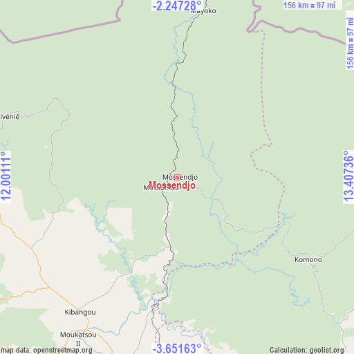
Mossendjo GPS coordinates[2]
2° 56' 58.848" South, 12° 42' 15.228" East
| Map corner | latitude | longitude |
|---|---|---|
| Upper-left | -2.24728°, | 12.00111° |
| Center: | -2.94968°, | 12.70423° |
| Lower-right: | -3.65163°, | 13.40736° |
| Map W x H: | 156.1×156.2 km | = 97×97.1mi |
| max Lat: | 1.64806° ⇑42.1% North |
| Mossendjo: | -2.94968° |
| min Lat: | ⇓57.9% South -4.77609° |
| min Long | Mossendjo | max Long |
| 11.8125° | 12.70423° | 18.05981° |
| W 21.1%⇐ | ⇒78.9% E |
Elevation
Elevation of Mossendjo is 448 m = 1470 ft, and this is 129 m = 423 ft above average elevation for this country.
| Max E: |
790 m = 2592 ft | 15.8% |
| Mossendjo | 448 m 1470 ft | |
| Avg. | 319 m = 1047 ft | |
Min E: |
7 m = 23 ft | 84.2% |
See also: Republic of the Congo elevation on elevation.city.
Geographical zone
Mossendjo is located in South Torrid zone (between Equator and Tropic of Capricorn). Distance of Equator is 328 km =203.8 mi to North.| Distance of | km | miles | from Mossendjo |
|---|---|---|---|
| Equator | 328 | 203.8 | to North |
| Tropic Capricorn | 2277.9 | 1415.4 | to South |
| Antarctic Circle | 7073.2 | 4395.1 | to South |
| South Pole | 9679.1 | 6014.3 | to South |


Nearby cities:
14 places around Mossendjo: (largest is in red/bold)
• Boukiéro
318.3 km =197.8 mi,  115°
115°
• Brazzaville
321.4 km =199.7 mi, 117°
• Djambala
232 km =144.2 mi,  78°
78°
• Dolisie
138.9 km =86.3 mi,  181°
181°
• Ewo
329.6 km =204.8 mi,  45°
45°
• Gamboma
370.8 km =230.4 mi,  71°
71°
• Kayes
153.8 km =95.6 mi,  155°
155°
• Kinkala
277.3 km =172.3 mi, 124°
• Loandjili
221.7 km =137.8 mi,  205°
205°
• Loango
213.6 km =132.7 mi, 207°
• Madingou
163.5 km =101.6 mi,  144°
144°
• Nkayi
151.7 km =94.3 mi,  154°
154°
• Pointe-Noire
223.5 km =138.9 mi,  204°
204°
• Sibiti
108.5 km =67.4 mi, 138°
Sources, notices
• [Note1] Compared only with cities in Republic of the Congo existing in our database
• [Src1] Map data: © OpenStreetMap contributors (CC-BY-SA)
• [Src2] Other city data from geonames.org with taken over terms of usage.
• [Src3] Geographical zone / Annual Mean Temperature by Robert A. Rohde @ Wikipedia
