Nkayi geodata
Nkayi (Bouenza) is a seat of a second-order administrative division; located in Republic of the Congo in Africa/Brazzaville (GMT+1) time zone. In our database, there are 18 cities with bigger population. Compared to other cities in Republic of the Congo, 57.9% of cities are located further ↑North; 73.7% of cities are located further →East and 78.9% of cities have higher elevation than Nkayi. Note1


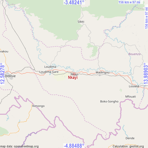
Nkayi GPS coordinates[2]
4° 11' 2.256" South, 13° 17' 9.24" East
| Map corner | latitude | longitude |
|---|---|---|
| Upper-left | -3.48241°, | 12.58278° |
| Center: | -4.18396°, | 13.2859° |
| Lower-right: | -4.88488°, | 13.98903° |
| Map W x H: | 155.9×155.9 km | = 96.9×96.9mi |
| max Lat: | 1.64806° ⇑57.9% North |
| Nkayi: | -4.18396° |
| min Lat: | ⇓42.1% South -4.77609° |
| min Long | Nkayi | max Long |
| 11.8125° | 13.2859° | 18.05981° |
| W 26.3%⇐ | ⇒73.7% E |
Elevation
Elevation of Nkayi is 181 m = 594 ft, and this is 138 m = 453 ft below average elevation for this country.
| Max E: |
790 m = 2592 ft | 78.9% |
| Avg. | 319 m = 1047 ft | |
| Nkayi | 181 m = 594 ft | |
Min E: |
7 m = 23 ft | 21.1% |
See also: Republic of the Congo elevation on elevation.city.
Geographical zone
Nkayi is located in South Torrid zone (between Equator and Tropic of Capricorn). Distance of Equator is 465.2 km =289.1 mi to North.| Distance of | km | miles | from Nkayi |
|---|---|---|---|
| Equator | 465.2 | 289.1 | to North |
| Tropic Capricorn | 2140.7 | 1330.2 | to South |
| Antarctic Circle | 6936 | 4309.8 | to South |
| South Pole | 9541.8 | 5929 | to South |


Nearby cities:
14 places around Nkayi: (largest is in red/bold)
• Boukiéro
221.7 km =137.8 mi,  90°
90°
• Brazzaville
221.7 km =137.8 mi, 92°
• Djambala
244.4 km =151.9 mi,  41°
41°
• Dolisie
68.7 km =42.7 mi,  268°
268°
• Ewo
405.7 km =252.1 mi,  24°
24°
• Gamboma
384.4 km =238.9 mi,  48°
48°
• Kayes
2.3 km =1.4 mi,  179°
179°
• Kinkala
165.1 km =102.6 mi,  96°
96°
• Loandjili
170.6 km =106 mi,  248°
248°
• Loango
171.4 km =106.5 mi, 252°
• Madingou
29.5 km =18.3 mi,  83°
83°
• Mossendjo
151.7 km =94.3 mi,  334°
334°
• Pointe-Noire
170.9 km =106.2 mi, 247°
• Sibiti
56.3 km =35 mi,  7°
7°
Sources, notices
• [Note1] Compared only with cities in Republic of the Congo existing in our database
• [Src1] Map data: © OpenStreetMap contributors (CC-BY-SA)
• [Src2] Other city data from geonames.org with taken over terms of usage.
• [Src3] Geographical zone / Annual Mean Temperature by Robert A. Rohde @ Wikipedia
