Kinkala geodata
Kinkala (Pool) is a seat of a first-order administrative division; located in Republic of the Congo in Africa/Brazzaville (GMT+1) time zone. With population of 13,882 people, there are 12 cities with bigger population in this country. Compared to other cities in Republic of the Congo, 84.2% of cities are located further ↑North; 57.9% of cities are located further ←West and 73.7% of cities have lower elevation than Kinkala. Note1


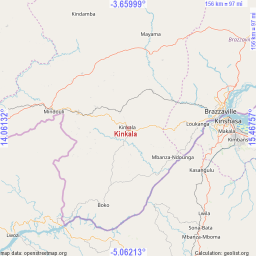
Kinkala GPS coordinates[2]
4° 21' 41.004" South, 14° 45' 51.984" East
| Map corner | latitude | longitude |
|---|---|---|
| Upper-left | -3.65999°, | 14.06132° |
| Center: | -4.36139°, | 14.76444° |
| Lower-right: | -5.06213°, | 15.46757° |
| Map W x H: | 155.9×155.9 km | = 96.9×96.9mi |
| max Lat: | 1.64806° ⇑84.2% North |
| Kinkala: | -4.36139° |
| min Lat: | ⇓15.8% South -4.77609° |
| min Long | Kinkala | max Long |
| 11.8125° | 14.76444° | 18.05981° |
| W 57.9%⇐ | ⇒42.1% E |
Elevation
Elevation of Kinkala is 426 m = 1398 ft, and this is 107 m = 351 ft above average elevation for this country.
| Max E: |
790 m = 2592 ft | 26.3% |
| Kinkala | 426 m 1398 ft | |
| Avg. | 319 m = 1047 ft | |
Min E: |
7 m = 23 ft | 73.7% |
See also: Republic of the Congo elevation on elevation.city.
Geographical zone
Kinkala is located in South Torrid zone (between Equator and Tropic of Capricorn). Distance of Equator is 484.9 km =301.3 mi to North.| Distance of | km | miles | from Kinkala |
|---|---|---|---|
| Equator | 484.9 | 301.3 | to North |
| Tropic Capricorn | 2121 | 1317.9 | to South |
| Antarctic Circle | 6916.2 | 4297.5 | to South |
| South Pole | 9522.1 | 5916.8 | to South |


Nearby cities:
14 places around Kinkala: (largest is in red/bold)
• Boukiéro
60.5 km =37.6 mi,  72°
72°
• Brazzaville
58.5 km =36.4 mi,  79°
79°
• Djambala
202 km =125.5 mi,  359°
359°
• Dolisie
233.3 km =145 mi,  274°
274°
• Ewo
388 km =241.1 mi,  0°
0°
• Gamboma
302.1 km =187.7 mi,  23°
23°
• Kayes
164.8 km =102.4 mi,  276°
276°
• Loandjili
325.1 km =202 mi,  262°
262°
• Loango
328.8 km =204.3 mi, 264°
• Madingou
136.6 km =84.9 mi, 279°
• Mossendjo
277.3 km =172.3 mi,  304°
304°
• Nkayi
165.1 km =102.6 mi, 276°
• Pointe-Noire
324.8 km =201.8 mi, 261°
• Sibiti
174.1 km =108.2 mi, 295°
Sources, notices
• [Note1] Compared only with cities in Republic of the Congo existing in our database
• [Src1] Map data: © OpenStreetMap contributors (CC-BY-SA)
• [Src2] Other city data from geonames.org with taken over terms of usage.
• [Src3] Geographical zone / Annual Mean Temperature by Robert A. Rohde @ Wikipedia
