Brazzaville geodata
Brazzaville is a capital of a political entity; located in Republic of the Congo in Africa/Brazzaville (GMT+1) time zone. With population of 1,284,609 people, there are 0 cities with bigger population in this country. Compared to other cities in Republic of the Congo, 78.9% of cities are located further ↑North; 68.4% of cities are located further ←West and 68.4% of cities have higher elevation than Brazzaville. Note1


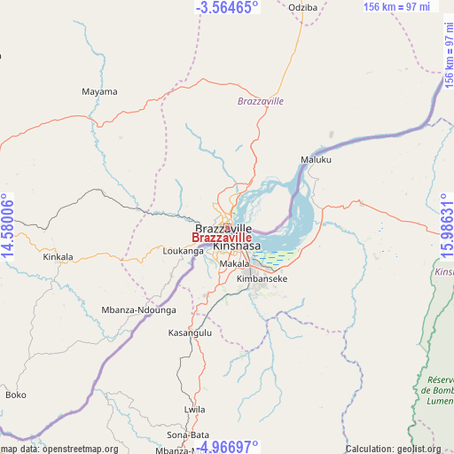
Brazzaville GPS coordinates[2]
4° 15' 58.068" South, 15° 16' 59.448" East
| Map corner | latitude | longitude |
|---|---|---|
| Upper-left | -3.56465°, | 14.58006° |
| Center: | -4.26613°, | 15.28318° |
| Lower-right: | -4.96697°, | 15.98631° |
| Map W x H: | 155.9×155.9 km | = 96.9×96.9mi |
| max Lat: | 1.64806° ⇑78.9% North |
| Brazzaville: | -4.26613° |
| min Lat: | ⇓21.1% South -4.77609° |
| min Long | Brazzaville | max Long |
| 11.8125° | 15.28318° | 18.05981° |
| W 68.4%⇐ | ⇒31.6% E |
Elevation
Elevation of Brazzaville is 284 m = 932 ft, and this is 35 m = 115 ft below average elevation for this country.
| Max E: |
790 m = 2592 ft | 68.4% |
| Avg. | 319 m = 1047 ft | |
| Brazzaville | 284 m = 932 ft | |
Min E: |
7 m = 23 ft | 31.6% |
See also: Brazzaville elevation on elevation.city.
Geographical zone
Brazzaville is located in South Torrid zone (between Equator and Tropic of Capricorn). Distance of Equator is 474.3 km =294.7 mi to North.| Distance of | km | miles | from Brazzaville |
|---|---|---|---|
| Equator | 474.3 | 294.7 | to North |
| Tropic Capricorn | 2131.6 | 1324.5 | to South |
| Antarctic Circle | 6926.8 | 4304.1 | to South |
| South Pole | 9532.7 | 5923.3 | to South |


Nearby cities:
15 places around Brazzaville: (largest is in red/bold)
• Boukiéro
7.5 km =4.7 mi,  1°
1°
• Djambala
200.2 km =124.4 mi,  342°
342°
• Dolisie
290.2 km =180.3 mi,  271°
271°
• Ewo
380.8 km =236.6 mi,  352°
352°
• Gamboma
273.4 km =169.9 mi,  13°
13°
• Kayes
221.6 km =137.7 mi, 271°
• Kinkala
58.5 km =36.4 mi,  259°
259°
• Loandjili
383.6 km =238.4 mi, 261°
• Loango
387.1 km =240.5 mi, 263°
• Madingou
192.6 km =119.7 mi, 273°
• Mossendjo
321.4 km =199.7 mi,  297°
297°
• Nkayi
221.7 km =137.8 mi, 272°
• Owando
426.3 km =264.9 mi, 9°
• Pointe-Noire
383.3 km =238.2 mi, 261°
• Sibiti
224.1 km =139.2 mi,  286°
286°
Sources, notices
• [Note1] Compared only with cities in Republic of the Congo existing in our database
• [Src1] Map data: © OpenStreetMap contributors (CC-BY-SA)
• [Src2] Other city data from geonames.org with taken over terms of usage.
• [Src3] Geographical zone / Annual Mean Temperature by Robert A. Rohde @ Wikipedia
