Dolisie geodata
Dolisie (Niari) is a seat of a first-order administrative division; located in Republic of the Congo in Africa/Brazzaville (GMT+1) time zone. With population of 103,894 people, there are 2 cities with bigger population in this country. Compared to other cities in Republic of the Congo, 63.2% of cities are located further ↑North; 84.2% of cities are located further →East and 52.6% of cities have higher elevation than Dolisie. Note1


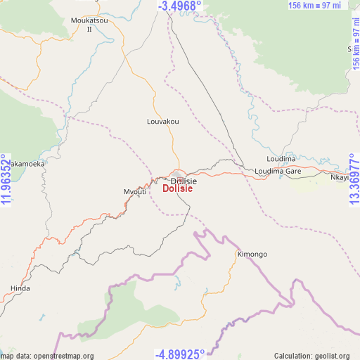
Dolisie GPS coordinates[2]
4° 11' 54.024" South, 12° 39' 59.904" East
| Map corner | latitude | longitude |
|---|---|---|
| Upper-left | -3.4968°, | 11.96352° |
| Center: | -4.19834°, | 12.66664° |
| Lower-right: | -4.89925°, | 13.36977° |
| Map W x H: | 155.9×155.9 km | = 96.9×96.9mi |
| max Lat: | 1.64806° ⇑63.2% North |
| Dolisie: | -4.19834° |
| min Lat: | ⇓36.8% South -4.77609° |
| min Long | Dolisie | max Long |
| 11.8125° | 12.66664° | 18.05981° |
| W 15.8%⇐ | ⇒84.2% E |
Elevation
Elevation of Dolisie is 332 m = 1089 ft, and this is 13 m = 43 ft above average elevation for this country.
| Max E: |
790 m = 2592 ft | 52.6% |
| Dolisie | 332 m 1089 ft | |
| Avg. | 319 m = 1047 ft | |
Min E: |
7 m = 23 ft | 47.4% |
See also: Dolisie elevation on elevation.city.
Geographical zone
Dolisie is located in South Torrid zone (between Equator and Tropic of Capricorn). Distance of Equator is 466.8 km =290.1 mi to North.| Distance of | km | miles | from Dolisie |
|---|---|---|---|
| Equator | 466.8 | 290.1 | to North |
| Tropic Capricorn | 2139.1 | 1329.2 | to South |
| Antarctic Circle | 6934.4 | 4308.8 | to South |
| South Pole | 9540.3 | 5928.1 | to South |


Nearby cities:
14 places around Dolisie: (largest is in red/bold)
• Boukiéro
290.4 km =180.4 mi,  90°
90°
• Brazzaville
290.2 km =180.3 mi, 91°
• Djambala
295.7 km =183.7 mi,  51°
51°
• Ewo
440.4 km =273.7 mi,  32°
32°
• Gamboma
439 km =272.8 mi, 53°
• Kayes
68.7 km =42.7 mi, 90°
• Kinkala
233.3 km =145 mi, 94°
• Loandjili
109 km =67.7 mi,  235°
235°
• Loango
107.3 km =66.7 mi, 241°
• Madingou
98.1 km =61 mi, 87°
• Mossendjo
138.9 km =86.3 mi,  1°
1°
• Nkayi
68.7 km =42.7 mi, 88°
• Pointe-Noire
109.8 km =68.2 mi,  234°
234°
• Sibiti
95.1 km =59.1 mi, 52°
Sources, notices
• [Note1] Compared only with cities in Republic of the Congo existing in our database
• [Src1] Map data: © OpenStreetMap contributors (CC-BY-SA)
• [Src2] Other city data from geonames.org with taken over terms of usage.
• [Src3] Geographical zone / Annual Mean Temperature by Robert A. Rohde @ Wikipedia
