Lostorf geodata
Lostorf (Solothurn) is a populated place; located in Switzerland in Europe/Zurich (GMT+2) time zone. With population of 3,749 people, there are 473 cities with bigger population in this country. Compared to other cities in Switzerland, 69.7% of cities are located further ↓South; 61.5% of cities are located further →East and 70.2% of cities have higher elevation than Lostorf. Note1


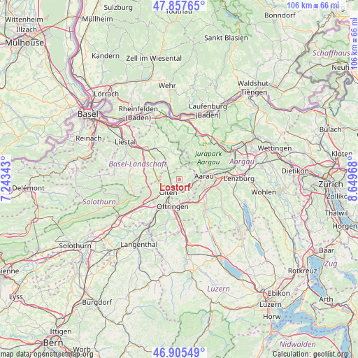
Lostorf GPS coordinates[2]
47° 23' 1.392" North, 7° 56' 47.58" East
| Map corner | latitude | longitude |
|---|---|---|
| Upper-left | 47.85765°, | 7.24343° |
| Center: | 47.38372°, | 7.94655° |
| Lower-right: | 46.90549°, | 8.64968° |
| Map W x H: | 105.9×105.9 km | = 65.8×65.8mi |
| max Lat: | 47.76737° ⇑30.3% North |
| Lostorf: | 47.38372° |
| min Lat: | ⇓69.7% South 45.83203° |
| min Long | Lostorf | max Long |
| 5.97153° | 7.94655° | 10.44624° |
| W 38.5%⇐ | ⇒61.5% E |
Elevation
Elevation of Lostorf is 439 m = 1440 ft, and this is 119.2 m = 391 ft below average elevation for this country.
| Max E: |
1845 m = 6053 ft | 70.2% |
| Avg. | 558.2 m = 1831 ft | |
| Lostorf | 439 m = 1440 ft | |
Min E: |
197 m = 646 ft | 29.8% |
See also: Switzerland elevation on elevation.city.
Geographical zone
Lostorf is located in North temperate zone (between Tropic of Cancer and the Arctic Circle). Distance of this North polar circle is 2132.6 km =1325.1 mi to North.| Distance of | km | miles | from Lostorf |
|---|---|---|---|
| North Pole | 4738.5 | 2944.4 | to North |
| Arctic Circle | 2132.6 | 1325.1 | to North |
| Tropic Cancer | 2662.7 | 1654.5 | to South |
| Equator | 5268.6 | 3273.8 | to South |


Nearby cities:
15 places around Lostorf: (largest is in red/bold)
• Aarau
7.4 km =4.6 mi,  82°
82°
• Aarburg
7.8 km =4.8 mi,  206°
206°
• Erlinsbach
4.9 km =3 mi,  71°
71°
• Läufelfingen
6.9 km =4.3 mi,  280°
280°
• Niedergösgen
3.4 km =2.1 mi,  113°
113°
• Obergösgen
2.1 km =1.3 mi,  169°
169°
• Oftringen
7.9 km =4.9 mi,  191°
191°
• Olten
5 km =3.1 mi,  220°
220°
• Rohr
3 km =1.9 mi,  9°
9°
• Rünenberg
7.3 km =4.5 mi,  318°
318°
• Safenwil
7.4 km =4.6 mi,  158°
158°
• Schönenwerd
4.5 km =2.8 mi, 111°
• Trimbach
4.9 km =3 mi,  245°
245°
• Wangen
7.3 km =4.5 mi,  232°
232°
• Zeglingen
4.8 km =3 mi, 320°
Sources, notices
• [Note1] Compared only with cities in Switzerland existing in our database
• [Src1] Map data: © OpenStreetMap contributors (CC-BY-SA)
• [Src2] Other city data from geonames.org with taken over terms of usage.
• [Src3] Geographical zone / Annual Mean Temperature by Robert A. Rohde @ Wikipedia
