Mankono geodata
Mankono (Woroba) is a seat of a second-order administrative division; located in Ivory Coast in Africa/Abidjan (GMT+0) time zone. With population of 19,095 people, there are 51 cities with bigger population in this country. Compared to other cities in Ivory Coast, 76.1% of cities are located further ↓South; 67.5% of cities are located further →East and 77.8% of cities have lower elevation than Mankono. Note1


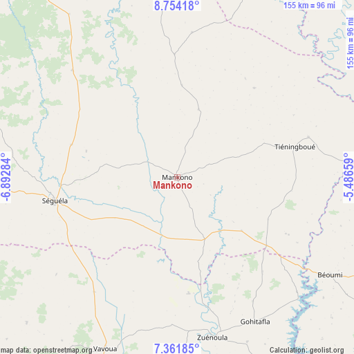
Mankono GPS coordinates[2]
8° 3' 30.996" North, 6° 11' 22.992" West
| Map corner | latitude | longitude |
|---|---|---|
| Upper-left | 8.75418°, | -6.89284° |
| Center: | 8.05861°, | -6.18972° |
| Lower-right: | 7.36185°, | -5.48659° |
| Map W x H: | 154.8×154.8 km | = 96.2×96.2mi |
| max Lat: | 10.48115° ⇑23.9% North |
| Mankono: | 8.05861° |
| min Lat: | ⇓76.1% South 4.42295° |
| min Long | Mankono | max Long |
| -8.42592° | -6.18972° | -2.80003° |
| W 32.5%⇐ | ⇒67.5% E |
Elevation
Elevation of Mankono is 335 m = 1099 ft, and this is 110.7 m = 363 ft above average elevation for this country.
| Max E: |
556 m = 1824 ft | 22.2% |
| Mankono | 335 m 1099 ft | |
| Avg. | 224.3 m = 736 ft | |
Min E: |
7 m = 23 ft | 77.8% |
See also: Ivory Coast elevation on elevation.city.
Geographical zone
Mankono is located in North Torrid zone (between Equator and Tropic of Cancer). Distance of Equator is 896 km =556.7 mi to South.| Distance of | km | miles | from Mankono |
|---|---|---|---|
| North Pole | 9111 | 5661.3 | to North |
| Arctic Circle | 6505.1 | 4042.1 | to North |
| Tropic Cancer | 1709.9 | 1062.5 | to North |
| Equator | 896 | 556.7 | to South |


Nearby cities:
15 places around Mankono: (largest is in red/bold)
• Botro
99.5 km =61.8 mi,  103°
103°
• Bouaflé
128.5 km =79.8 mi,  157°
157°
• Bouaké
134 km =83.3 mi,  107°
107°
• Béoumi
79.5 km =49.4 mi,  122°
122°
• Daloa
134.4 km =83.5 mi,  192°
192°
• Dianra
98.6 km =61.3 mi,  355°
355°
• Dikodougou
121.2 km =75.3 mi,  22°
22°
• Kani
65.3 km =40.6 mi,  315°
315°
• Katiola
120.2 km =74.7 mi,  85°
85°
• Kounahiri
49.1 km =30.5 mi,  127°
127°
• Niakaramandougou
119.2 km =74.1 mi,  56°
56°
• Sakassou
119.5 km =74.3 mi, 124°
• Séguéla
54.3 km =33.7 mi,  258°
258°
• Vavoua
81.7 km =50.8 mi,  202°
202°
• Zuénoula
71.5 km =44.4 mi,  167°
167°
Sources, notices
• [Note1] Compared only with cities in Ivory Coast existing in our database
• [Src1] Map data: © OpenStreetMap contributors (CC-BY-SA)
• [Src2] Other city data from geonames.org with taken over terms of usage.
• [Src3] Geographical zone / Annual Mean Temperature by Robert A. Rohde @ Wikipedia
