Maféré geodata
Maféré (Comoé) is a seat of a fourth-order administrative division; located in Ivory Coast in Africa/Abidjan (GMT+0) time zone. In our database, there are 63 cities with bigger population. Compared to other cities in Ivory Coast, 88% of cities are located further ↑North; 96.6% of cities are located further ←West and 74.4% of cities have higher elevation than Maféré. Note1


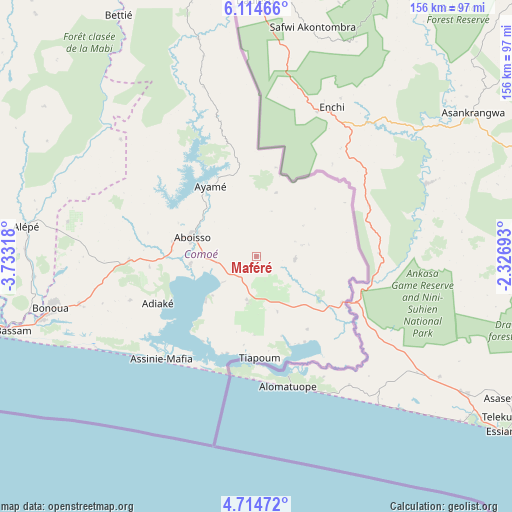
Maféré GPS coordinates[2]
5° 24' 54.36" North, 3° 1' 48.216" West
| Map corner | latitude | longitude |
|---|---|---|
| Upper-left | 6.11466°, | -3.73318° |
| Center: | 5.4151°, | -3.03006° |
| Lower-right: | 4.71472°, | -2.32693° |
| Map W x H: | 155.7×155.7 km | = 96.7×96.7mi |
| max Lat: | 10.48115° ⇑88% North |
| Maféré: | 5.4151° |
| min Lat: | ⇓12% South 4.42295° |
| min Long | Maféré | max Long |
| -8.42592° | -3.03006° | -2.80003° |
| W 96.6%⇐ | ⇒3.4% E |
Elevation
Elevation of Maféré is 122 m = 400 ft, and this is 102.3 m = 336 ft below average elevation for this country.
| Max E: |
556 m = 1824 ft | 74.4% |
| Avg. | 224.3 m = 736 ft | |
| Maféré | 122 m = 400 ft | |
Min E: |
7 m = 23 ft | 25.6% |
See also: Ivory Coast elevation on elevation.city.
Geographical zone
Maféré is located in North Torrid zone (between Equator and Tropic of Cancer). Distance of Equator is 602.1 km =374.1 mi to South.| Distance of | km | miles | from Maféré |
|---|---|---|---|
| North Pole | 9405 | 5844 | to North |
| Arctic Circle | 6799.1 | 4224.8 | to North |
| Tropic Cancer | 2003.8 | 1245.1 | to North |
| Equator | 602.1 | 374.1 | to South |


Nearby cities:
15 places around Maféré: (largest is in red/bold)
• Abidjan
109.4 km =68 mi,  263°
263°
• Abobo
109.1 km =67.8 mi,  270°
270°
• Aboisso
20.5 km =12.7 mi,  286°
286°
• Adiaké
33.5 km =20.8 mi,  244°
244°
• Agou
119.2 km =74.1 mi,  301°
301°
• Alépé
70.7 km =43.9 mi,  277°
277°
• Anyama
113.4 km =70.5 mi, 274°
• Ayamé
25.4 km =15.8 mi,  326°
326°
• Azaguié
118.8 km =73.8 mi, 281°
• Bingerville
94.9 km =59 mi, 266°
• Bonoua
64.7 km =40.2 mi, 255°
• Béttié
84.5 km =52.5 mi, 330°
• Grand-Bassam
81.7 km =50.8 mi,  253°
253°
• Tiapoum
31 km =19.3 mi,  178°
178°
• Yakassé-Attobrou
109.5 km =68 mi,  321°
321°
Sources, notices
• [Note1] Compared only with cities in Ivory Coast existing in our database
• [Src1] Map data: © OpenStreetMap contributors (CC-BY-SA)
• [Src2] Other city data from geonames.org with taken over terms of usage.
• [Src3] Geographical zone / Annual Mean Temperature by Robert A. Rohde @ Wikipedia
