Adiaké geodata
Adiaké (Comoé) is a seat of a third-order administrative division; located in Ivory Coast in Africa/Abidjan (GMT+0) time zone. With population of 16,531 people, there are 54 cities with bigger population in this country. Compared to other cities in Ivory Coast, 92.3% of cities are located further ↑North; 91.5% of cities are located further ←West and 88% of cities have higher elevation than Adiaké. Note1


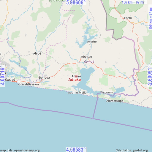
Adiaké GPS coordinates[2]
5° 17' 10.824" North, 3° 18' 14.508" West
| Map corner | latitude | longitude |
|---|---|---|
| Upper-left | 5.98606°, | -4.00716° |
| Center: | 5.28634°, | -3.30403° |
| Lower-right: | 4.58583°, | -2.60091° |
| Map W x H: | 155.7×155.7 km | = 96.7×96.7mi |
| max Lat: | 10.48115° ⇑92.3% North |
| Adiaké: | 5.28634° |
| min Lat: | ⇓7.7% South 4.42295° |
| min Long | Adiaké | max Long |
| -8.42592° | -3.30403° | -2.80003° |
| W 91.5%⇐ | ⇒8.5% E |
Elevation
Elevation of Adiaké is 40 m = 131 ft, and this is 184.3 m = 605 ft below average elevation for this country.
| Max E: |
556 m = 1824 ft | 88% |
| Avg. | 224.3 m = 736 ft | |
| Adiaké | 40 m = 131 ft | |
Min E: |
7 m = 23 ft | 12% |
See also: Ivory Coast elevation on elevation.city.
Geographical zone
Adiaké is located in North Torrid zone (between Equator and Tropic of Cancer). Distance of Equator is 587.8 km =365.2 mi to South.| Distance of | km | miles | from Adiaké |
|---|---|---|---|
| North Pole | 9419.3 | 5852.9 | to North |
| Arctic Circle | 6813.4 | 4233.6 | to North |
| Tropic Cancer | 2018.1 | 1254 | to North |
| Equator | 587.8 | 365.2 | to South |


Nearby cities:
15 places around Adiaké: (largest is in red/bold)
• Abidjan
78.5 km =48.8 mi,  271°
271°
• Abobo
80.1 km =49.8 mi,  280°
280°
• Aboisso
22.9 km =14.2 mi,  28°
28°
• Agou
104.9 km =65.2 mi,  317°
317°
• Alépé
46.3 km =28.8 mi,  300°
300°
• Anyama
86 km =53.4 mi,  285°
285°
• Ayamé
39 km =24.2 mi,  24°
24°
• Azaguié
94.2 km =58.5 mi, 293°
• Bingerville
64.8 km =40.3 mi, 276°
• Bonoua
32.4 km =20.1 mi, 267°
• Béttié
88.5 km =55 mi,  352°
352°
• Grand-Bassam
48.9 km =30.4 mi,  260°
260°
• Maféré
33.5 km =20.8 mi,  64°
64°
• Songon
105.3 km =65.4 mi, 272°
• Tiapoum
35.3 km =21.9 mi,  118°
118°
Sources, notices
• [Note1] Compared only with cities in Ivory Coast existing in our database
• [Src1] Map data: © OpenStreetMap contributors (CC-BY-SA)
• [Src2] Other city data from geonames.org with taken over terms of usage.
• [Src3] Geographical zone / Annual Mean Temperature by Robert A. Rohde @ Wikipedia
