Ayamé geodata
Ayamé (Comoé) is a seat of a fourth-order administrative division; located in Ivory Coast in Africa/Abidjan (GMT+0) time zone. With population of 12,315 people, there are 61 cities with bigger population in this country. Compared to other cities in Ivory Coast, 82.9% of cities are located further ↑North; 95.7% of cities are located further ←West and 82.9% of cities have higher elevation than Ayamé. Note1


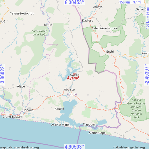
Ayamé GPS coordinates[2]
5° 36' 18.72" North, 3° 9' 25.524" West
| Map corner | latitude | longitude |
|---|---|---|
| Upper-left | 6.30453°, | -3.86022° |
| Center: | 5.6052°, | -3.15709° |
| Lower-right: | 4.90503°, | -2.45397° |
| Map W x H: | 155.6×155.6 km | = 96.7×96.7mi |
| max Lat: | 10.48115° ⇑82.9% North |
| Ayamé: | 5.6052° |
| min Lat: | ⇓17.1% South 4.42295° |
| min Long | Ayamé | max Long |
| -8.42592° | -3.15709° | -2.80003° |
| W 95.7%⇐ | ⇒4.3% E |
Elevation
Elevation of Ayamé is 82 m = 269 ft, and this is 142.3 m = 467 ft below average elevation for this country.
| Max E: |
556 m = 1824 ft | 82.9% |
| Avg. | 224.3 m = 736 ft | |
| Ayamé | 82 m = 269 ft | |
Min E: |
7 m = 23 ft | 17.1% |
See also: Ivory Coast elevation on elevation.city.
Geographical zone
Ayamé is located in North Torrid zone (between Equator and Tropic of Cancer). Distance of Equator is 623.2 km =387.2 mi to South.| Distance of | km | miles | from Ayamé |
|---|---|---|---|
| North Pole | 9383.8 | 5830.8 | to North |
| Arctic Circle | 6777.9 | 4211.6 | to North |
| Tropic Cancer | 1982.7 | 1232 | to North |
| Equator | 623.2 | 387.2 | to South |


Nearby cities:
15 places around Ayamé: (largest is in red/bold)
• Abidjan
100.2 km =62.3 mi,  250°
250°
• Abobo
97.3 km =60.5 mi,  257°
257°
• Aboisso
16.3 km =10.1 mi,  199°
199°
• Adiaké
39 km =24.2 mi, 204°
• Adzopé
95.9 km =59.6 mi,  305°
305°
• Agou
96.6 km =60 mi,  295°
295°
• Alépé
57.2 km =35.5 mi, 258°
• Anyama
99.8 km =62 mi, 262°
• Bingerville
85.2 km =52.9 mi, 251°
• Bonoua
61.1 km =38 mi,  232°
232°
• Béttié
59.2 km =36.8 mi,  332°
332°
• Grand-Bassam
77.8 km =48.3 mi,  235°
235°
• Maféré
25.4 km =15.8 mi,  146°
146°
• Tiapoum
54.2 km =33.7 mi,  164°
164°
• Yakassé-Attobrou
84.2 km =52.3 mi,  319°
319°
Sources, notices
• [Note1] Compared only with cities in Ivory Coast existing in our database
• [Src1] Map data: © OpenStreetMap contributors (CC-BY-SA)
• [Src2] Other city data from geonames.org with taken over terms of usage.
• [Src3] Geographical zone / Annual Mean Temperature by Robert A. Rohde @ Wikipedia
