Talca geodata
Talca (Maule Region) is a seat of a first-order administrative division; located in Chile in America/Santiago (GMT-4) time zone. With population of 197,479 people, there are 12 cities with bigger population in this country. Compared to other cities in Chile, 54.5% of cities are located further ↓South; 51.7% of cities are located further ←West and 57.9% of cities have higher elevation than Talca. Note1


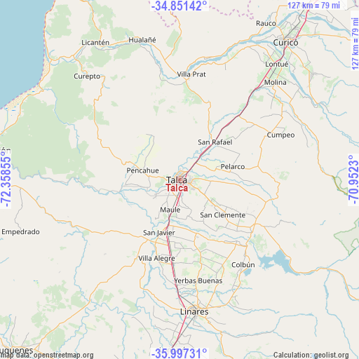
Talca GPS coordinates[2]
35° 25' 35.04" South, 71° 39' 19.512" West
| Map corner | latitude | longitude |
|---|---|---|
| Upper-left | -34.85142°, | -72.35855° |
| Center: | -35.4264°, | -71.65542° |
| Lower-right: | -35.99731°, | -70.9523° |
| Map W x H: | 127.4×127.4 km | = 79.2×79.2mi |
| max Lat: | -18.19821° ⇑45.5% North |
| Talca: | -35.4264° |
| min Lat: | ⇓54.5% South -54.93355° |
| min Long | Talca | max Long |
| -109.42438° | -71.65542° | -67.60963° |
| W 51.7%⇐ | ⇒48.3% E |
Elevation
Elevation of Talca is 104 m = 341 ft, and this is 169 m = 554 ft below average elevation for this country.
| Max E: |
3544 m = 11627 ft | 57.9% |
| Avg. | 273 m = 896 ft | |
| Talca | 104 m = 341 ft | |
Min E: |
1 m = 3 ft | 42.1% |
See also: Talca elevation on elevation.city.
Geographical zone
Talca is located in South temperate zone (between Tropic of Capricorn and the Antarctic Circle). Distance of this Southern Tropic circle is 1333.1 km =828.3 mi to North.| Distance of | km | miles | from Talca |
|---|---|---|---|
| Equator | 3939 | 2447.6 | to North |
| Tropic Capricorn | 1333.1 | 828.3 | to North |
| Antarctic Circle | 3462.1 | 2151.2 | to South |
| South Pole | 6068 | 3770.5 | to South |


Nearby cities:
15 places around Talca: (largest is in red/bold)
• Cauquenes
85.1 km =52.9 mi,  225°
225°
• Chimbarongo
97 km =60.3 mi,  35°
35°
• Colbún
37.4 km =23.2 mi,  142°
142°
• Constitución
69.3 km =43.1 mi,  278°
278°
• Curicó
62.1 km =38.6 mi, 37°
• Linares
47.1 km =29.3 mi,  173°
173°
• Longaví
59.9 km =37.2 mi,  182°
182°
• Molina
48.5 km =30.1 mi, 44°
• Parral
81.2 km =50.5 mi,  190°
190°
• Rauco
63.6 km =39.5 mi,  28°
28°
• San Carlos
114.3 km =71 mi, 193°
• San Clemente
19.6 km =12.2 mi,  129°
129°
• San Javier
19.9 km =12.4 mi,  199°
199°
• Santa Cruz
91.5 km =56.9 mi,  16°
16°
• Teno
76.4 km =47.5 mi, 35°
Sources, notices
• [Note1] Compared only with cities in Chile existing in our database
• [Src1] Map data: © OpenStreetMap contributors (CC-BY-SA)
• [Src2] Other city data from geonames.org with taken over terms of usage.
• [Src3] Geographical zone / Annual Mean Temperature by Robert A. Rohde @ Wikipedia
