Colbún geodata
Colbún (Maule Region) is a populated place; located in Chile in America/Santiago (GMT-4) time zone. With population of 3,679 people, there are 120 cities with bigger population in this country. Compared to other cities in Chile, 52.4% of cities are located further ↓South; 57.2% of cities are located further ←West and 70.3% of cities have lower elevation than Colbún. Note1


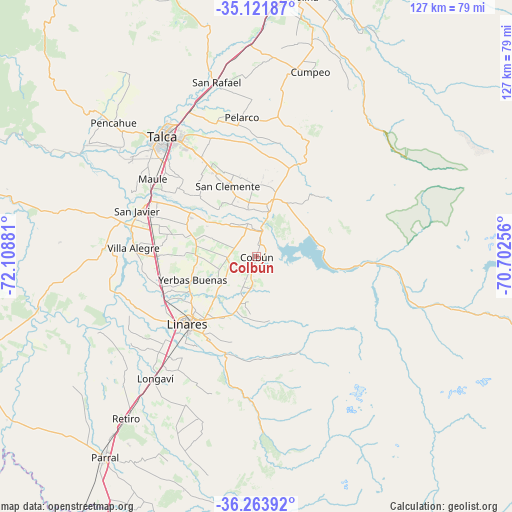
Colbún GPS coordinates[2]
35° 41' 41.784" South, 71° 24' 20.448" West
| Map corner | latitude | longitude |
|---|---|---|
| Upper-left | -35.12187°, | -72.10881° |
| Center: | -35.69494°, | -71.40568° |
| Lower-right: | -36.26392°, | -70.70256° |
| Map W x H: | 127×127 km | = 78.9×78.9mi |
| max Lat: | -18.19821° ⇑47.6% North |
| Colbún: | -35.69494° |
| min Lat: | ⇓52.4% South -54.93355° |
| min Long | Colbún | max Long |
| -109.42438° | -71.40568° | -67.60963° |
| W 57.2%⇐ | ⇒42.8% E |
Elevation
Elevation of Colbún is 260 m = 853 ft, and this is 13 m = 43 ft below average elevation for this country.
| Max E: |
3544 m = 11627 ft | 29.7% |
| Avg. | 273 m = 896 ft | |
| Colbún | 260 m = 853 ft | |
Min E: |
1 m = 3 ft | 70.3% |
See also: Chile elevation on elevation.city.
Geographical zone
Colbún is located in South temperate zone (between Tropic of Capricorn and the Antarctic Circle). Distance of this Southern Tropic circle is 1363 km =846.9 mi to North.| Distance of | km | miles | from Colbún |
|---|---|---|---|
| Equator | 3968.9 | 2466.2 | to North |
| Tropic Capricorn | 1363 | 846.9 | to North |
| Antarctic Circle | 3432.3 | 2132.7 | to South |
| South Pole | 6038.2 | 3752 | to South |


Nearby cities:
15 places around Colbún: (largest is in red/bold)
• Cauquenes
88 km =54.7 mi,  249°
249°
• Chimbarongo
114.1 km =70.9 mi,  16°
16°
• Coihueco
110.5 km =68.7 mi,  200°
200°
• Constitución
99.5 km =61.8 mi,  293°
293°
• Curicó
80.6 km =50.1 mi,  10°
10°
• Linares
23.9 km =14.9 mi,  225°
225°
• Longaví
39.1 km =24.3 mi,  219°
219°
• Molina
65.5 km =40.7 mi, 9°
• Parral
62.6 km =38.9 mi, 217°
• Rauco
85.9 km =53.4 mi, 5°
• San Carlos
95.1 km =59.1 mi,  211°
211°
• San Clemente
19 km =11.8 mi,  337°
337°
• San Javier
31.3 km =19.4 mi, 290°
• Talca
37.4 km =23.2 mi,  322°
322°
• Teno
94.3 km =58.6 mi, 13°
Sources, notices
• [Note1] Compared only with cities in Chile existing in our database
• [Src1] Map data: © OpenStreetMap contributors (CC-BY-SA)
• [Src2] Other city data from geonames.org with taken over terms of usage.
• [Src3] Geographical zone / Annual Mean Temperature by Robert A. Rohde @ Wikipedia
