Rauco geodata
Rauco (Maule Region) is a populated place; located in Chile in America/Santiago (GMT-4) time zone. With population of 8,566 people, there are 112 cities with bigger population in this country. Compared to other cities in Chile, 57.2% of cities are located further ↓South; 60% of cities are located further ←West and 59.3% of cities have lower elevation than Rauco. Note1


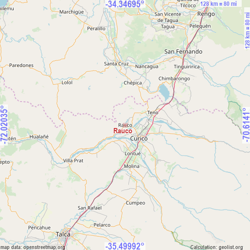
Rauco GPS coordinates[2]
34° 55' 31.656" South, 71° 19' 1.992" West
| Map corner | latitude | longitude |
|---|---|---|
| Upper-left | -34.34695°, | -72.02035° |
| Center: | -34.92546°, | -71.31722° |
| Lower-right: | -35.49992°, | -70.6141° |
| Map W x H: | 128.2×128.2 km | = 79.7×79.7mi |
| max Lat: | -18.19821° ⇑42.8% North |
| Rauco: | -34.92546° |
| min Lat: | ⇓57.2% South -54.93355° |
| min Long | Rauco | max Long |
| -109.42438° | -71.31722° | -67.60963° |
| W 60%⇐ | ⇒40% E |
Elevation
Elevation of Rauco is 195 m = 640 ft, and this is 78 m = 256 ft below average elevation for this country.
| Max E: |
3544 m = 11627 ft | 40.7% |
| Avg. | 273 m = 896 ft | |
| Rauco | 195 m = 640 ft | |
Min E: |
1 m = 3 ft | 59.3% |
See also: Chile elevation on elevation.city.
Geographical zone
Rauco is located in South temperate zone (between Tropic of Capricorn and the Antarctic Circle). Distance of this Southern Tropic circle is 1277.4 km =793.7 mi to North.| Distance of | km | miles | from Rauco |
|---|---|---|---|
| Equator | 3883.3 | 2413 | to North |
| Tropic Capricorn | 1277.4 | 793.7 | to North |
| Antarctic Circle | 3517.8 | 2185.9 | to South |
| South Pole | 6123.7 | 3805.1 | to South |


Nearby cities:
15 places around Rauco: (largest is in red/bold)
• Chimbarongo
34.4 km =21.4 mi,  46°
46°
• Colbún
85.9 km =53.4 mi,  185°
185°
• Curicó
9.5 km =5.9 mi,  131°
131°
• Linares
105.4 km =65.5 mi, 193°
• Machalí
102.9 km =63.9 mi,  36°
36°
• Molina
21.2 km =13.2 mi,  171°
171°
• Rancagua
99 km =61.5 mi,  32°
32°
• Rengo
71.4 km =44.4 mi, 36°
• San Clemente
69.8 km =43.4 mi, 192°
• San Javier
83.3 km =51.8 mi,  206°
206°
• San Vicente
58.8 km =36.5 mi,  21°
21°
• San Vicente de Tagua Tagua
58.4 km =36.3 mi, 22°
• Santa Cruz
32.2 km =20 mi,  352°
352°
• Talca
63.6 km =39.5 mi, 208°
• Teno
15.4 km =9.6 mi,  66°
66°
Sources, notices
• [Note1] Compared only with cities in Chile existing in our database
• [Src1] Map data: © OpenStreetMap contributors (CC-BY-SA)
• [Src2] Other city data from geonames.org with taken over terms of usage.
• [Src3] Geographical zone / Annual Mean Temperature by Robert A. Rohde @ Wikipedia
