San Javier geodata
San Javier (Maule Region) is a populated place; located in Chile in America/Santiago (GMT-4) time zone. With population of 22,427 people, there are 75 cities with bigger population in this country. Compared to other cities in Chile, 53.1% of cities are located further ↓South; 51% of cities are located further →East and 59.3% of cities have higher elevation than San Javier. Note1


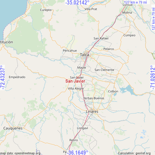
San Javier GPS coordinates[2]
35° 35' 42.72" South, 71° 43' 45.264" West
| Map corner | latitude | longitude |
|---|---|---|
| Upper-left | -35.02142°, | -72.43237° |
| Center: | -35.5952°, | -71.72924° |
| Lower-right: | -36.1649°, | -71.02612° |
| Map W x H: | 127.1×127.1 km | = 79×79mi |
| max Lat: | -18.19821° ⇑46.9% North |
| San Javier: | -35.5952° |
| min Lat: | ⇓53.1% South -54.93355° |
| min Long | San Javier | max Long |
| -109.42438° | -71.72924° | -67.60963° |
| W 49%⇐ | ⇒51% E |
Elevation
Elevation of San Javier is 101 m = 331 ft, and this is 172 m = 564 ft below average elevation for this country.
| Max E: |
3544 m = 11627 ft | 59.3% |
| Avg. | 273 m = 896 ft | |
| San Javier | 101 m = 331 ft | |
Min E: |
1 m = 3 ft | 40.7% |
See also: Chile elevation on elevation.city.
Geographical zone
San Javier is located in South temperate zone (between Tropic of Capricorn and the Antarctic Circle). Distance of this Southern Tropic circle is 1351.9 km =840 mi to North.| Distance of | km | miles | from San Javier |
|---|---|---|---|
| Equator | 3957.8 | 2459.3 | to North |
| Tropic Capricorn | 1351.9 | 840 | to North |
| Antarctic Circle | 3443.4 | 2139.6 | to South |
| South Pole | 6049.2 | 3758.8 | to South |


Nearby cities:
15 places around San Javier: (largest is in red/bold)
• Cauquenes
67.6 km =42 mi,  232°
232°
• Colbún
31.3 km =19.4 mi,  110°
110°
• Constitución
68.3 km =42.4 mi,  295°
295°
• Curicó
81.3 km =50.5 mi,  33°
33°
• Linares
30.5 km =19 mi,  156°
156°
• Longaví
41.3 km =25.7 mi,  174°
174°
• Molina
67.1 km =41.7 mi,  37°
37°
• Parral
61.5 km =38.2 mi,  188°
188°
• Quirihue
105.5 km =65.6 mi,  223°
223°
• Rauco
83.3 km =51.8 mi, 26°
• San Carlos
94.5 km =58.7 mi, 192°
• San Clemente
22.8 km =14.2 mi,  73°
73°
• Santa Cruz
111.4 km =69.2 mi,  17°
17°
• Talca
19.9 km =12.4 mi, 19°
• Teno
95.6 km =59.4 mi, 32°
In other languages:
- In Spanish: San Javier de Loncomilla
- In Italian: San Javier de Loncomilla
- In Russian: Сан-Хавьер-де-Лонкомилья
- In Chinese: 聖哈維爾
Sources, notices
• [Note1] Compared only with cities in Chile existing in our database
• [Src1] Map data: © OpenStreetMap contributors (CC-BY-SA)
• [Src2] Other city data from geonames.org with taken over terms of usage.
• [Src3] Geographical zone / Annual Mean Temperature by Robert A. Rohde @ Wikipedia
