Teno geodata
Teno (Maule Region) is a populated place; located in Chile in America/Santiago (GMT-4) time zone. With population of 6,858 people, there are 116 cities with bigger population in this country. Compared to other cities in Chile, 57.9% of cities are located further ↓South; 67.6% of cities are located further ←West and 73.1% of cities have lower elevation than Teno. Note1


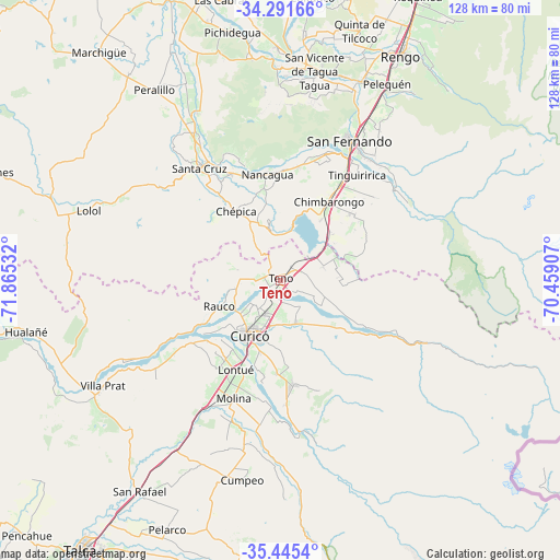
Teno GPS coordinates[2]
34° 52' 13.98" South, 71° 9' 43.884" West
| Map corner | latitude | longitude |
|---|---|---|
| Upper-left | -34.29166°, | -71.86532° |
| Center: | -34.87055°, | -71.16219° |
| Lower-right: | -35.4454°, | -70.45907° |
| Map W x H: | 128.3×128.3 km | = 79.7×79.7mi |
| max Lat: | -18.19821° ⇑42.1% North |
| Teno: | -34.87055° |
| min Lat: | ⇓57.9% South -54.93355° |
| min Long | Teno | max Long |
| -109.42438° | -71.16219° | -67.60963° |
| W 67.6%⇐ | ⇒32.4% E |
Elevation
Elevation of Teno is 297 m = 974 ft, and this is 24 m = 79 ft above average elevation for this country.
| Max E: |
3544 m = 11627 ft | 26.9% |
| Teno | 297 m 974 ft | |
| Avg. | 273 m = 896 ft | |
Min E: |
1 m = 3 ft | 73.1% |
See also: Chile elevation on elevation.city.
Geographical zone
Teno is located in South temperate zone (between Tropic of Capricorn and the Antarctic Circle). Distance of this Southern Tropic circle is 1271.3 km =789.9 mi to North.| Distance of | km | miles | from Teno |
|---|---|---|---|
| Equator | 3877.2 | 2409.2 | to North |
| Tropic Capricorn | 1271.3 | 789.9 | to North |
| Antarctic Circle | 3523.9 | 2189.6 | to South |
| South Pole | 6129.8 | 3808.9 | to South |


Nearby cities:
15 places around Teno: (largest is in red/bold)
• Chimbarongo
20.7 km =12.9 mi,  31°
31°
• Colbún
94.3 km =58.6 mi,  193°
193°
• Curicó
14.3 km =8.9 mi,  209°
209°
• Graneros
97.7 km =60.7 mi,  24°
24°
• Machalí
89.9 km =55.9 mi, 31°
• Molina
29.2 km =18.1 mi,  201°
201°
• Rancagua
86.7 km =53.9 mi, 26°
• Rauco
15.4 km =9.6 mi,  246°
246°
• Rengo
58.6 km =36.4 mi, 28°
• San Clemente
79.8 km =49.6 mi, 201°
• San Javier
95.6 km =59.4 mi, 212°
• San Vicente
49.1 km =30.5 mi,  8°
8°
• San Vicente de Tagua Tagua
48.6 km =30.2 mi, 9°
• Santa Cruz
31.8 km =19.8 mi,  324°
324°
• Talca
76.4 km =47.5 mi,  215°
215°
Sources, notices
• [Note1] Compared only with cities in Chile existing in our database
• [Src1] Map data: © OpenStreetMap contributors (CC-BY-SA)
• [Src2] Other city data from geonames.org with taken over terms of usage.
• [Src3] Geographical zone / Annual Mean Temperature by Robert A. Rohde @ Wikipedia
