Santa Cruz geodata
Santa Cruz (O'Higgins Region) is a populated place; located in Chile in America/Santiago (GMT-4) time zone. With population of 33,283 people, there are 50 cities with bigger population in this country. Compared to other cities in Chile, 59.3% of cities are located further ↓South; 58.6% of cities are located further ←West and 55.9% of cities have lower elevation than Santa Cruz. Note1
Administrative division(s):
- Level 1: O'Higgins Region
- Level 2: Provincia de Colchagua
- Level 3: Santa Cruz


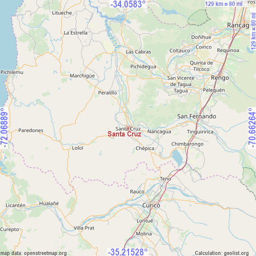
Santa Cruz GPS coordinates[2]
34° 38' 19.716" South, 71° 21' 56.736" West
| Map corner | latitude | longitude |
|---|---|---|
| Upper-left | -34.0583°, | -72.06889° |
| Center: | -34.63881°, | -71.36576° |
| Lower-right: | -35.21528°, | -70.66264° |
| Map W x H: | 128.6×128.6 km | = 79.9×79.9mi |
| max Lat: | -18.19821° ⇑40.7% North |
| Santa Cruz: | -34.63881° |
| min Lat: | ⇓59.3% South -54.93355° |
| min Long | Santa Cruz | max Long |
| -109.42438° | -71.36576° | -67.60963° |
| W 58.6%⇐ | ⇒41.4% E |
Elevation
Elevation of Santa Cruz is 174 m = 571 ft, and this is 99 m = 325 ft below average elevation for this country.
| Max E: |
3544 m = 11627 ft | 44.1% |
| Avg. | 273 m = 896 ft | |
| Santa Cruz | 174 m = 571 ft | |
Min E: |
1 m = 3 ft | 55.9% |
See also: Chile elevation on elevation.city.
Geographical zone
Santa Cruz is located in South temperate zone (between Tropic of Capricorn and the Antarctic Circle). Distance of this Southern Tropic circle is 1245.6 km =774 mi to North.| Distance of | km | miles | from Santa Cruz |
|---|---|---|---|
| Equator | 3851.5 | 2393.2 | to North |
| Tropic Capricorn | 1245.6 | 774 | to North |
| Antarctic Circle | 3549.7 | 2205.7 | to South |
| South Pole | 6155.6 | 3824.9 | to South |


Nearby cities:
15 places around Santa Cruz: (largest is in red/bold)
• Chimbarongo
30.6 km =19 mi,  105°
105°
• Curicó
39.9 km =24.8 mi,  163°
163°
• Graneros
86.3 km =53.6 mi,  42°
42°
• Machalí
83.1 km =51.6 mi,  52°
52°
• Melipilla
106.5 km =66.2 mi,  7°
7°
• Molina
53.4 km =33.2 mi,  171°
171°
• Paine
108.8 km =67.6 mi,  31°
31°
• Rancagua
77.2 km =48 mi, 47°
• Rauco
32.2 km =20 mi, 172°
• Rengo
53.2 km =33.1 mi,  60°
60°
• San Clemente
100.6 km =62.5 mi,  186°
186°
• San Vicente
34.5 km =21.4 mi, 48°
• San Vicente de Tagua Tagua
34.5 km =21.4 mi, 49°
• Talca
91.5 km =56.9 mi,  196°
196°
• Teno
31.8 km =19.8 mi,  144°
144°
Sources, notices
• [Note1] Compared only with cities in Chile existing in our database
• [Src1] Map data: © OpenStreetMap contributors (CC-BY-SA)
• [Src2] Other city data from geonames.org with taken over terms of usage.
• [Src3] Geographical zone / Annual Mean Temperature by Robert A. Rohde @ Wikipedia
